Tarantasca elevation
Tarantasca (Piedmont, Provincia di Cuneo), Italy elevation is 453 meters and Tarantasca elevation in feet is 1486 ft above sea level [src 1]. Tarantasca is a seat of a third-order administrative division (feature code) with elevation that is 131 meters (430 ft) bigger than average city elevation in Italy.
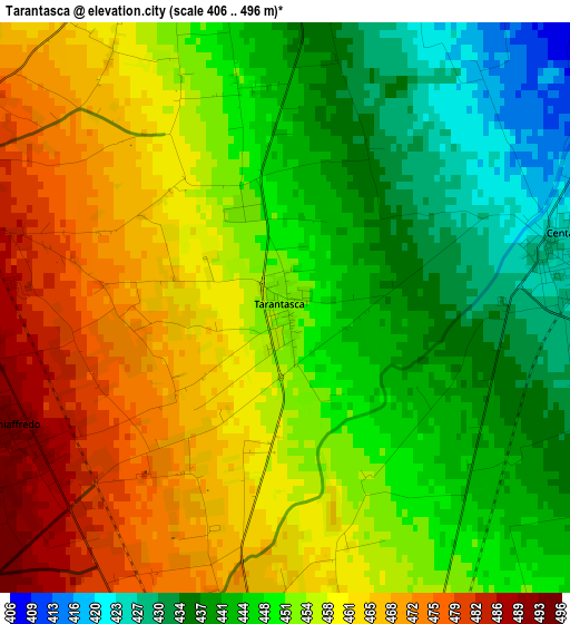
Below is the Elevation map of Tarantasca, which displays elevation range with different colors. Scale of the first map is from 406 to 496 m (1332 to 1627 ft) with average elevation of 453.3 meters (=1487 ft) [note 1]
These maps also provides idea of topography and contour of this city, they are displayed at different zoom levels. More info about maps, scale and edge coordinates you can find below images.
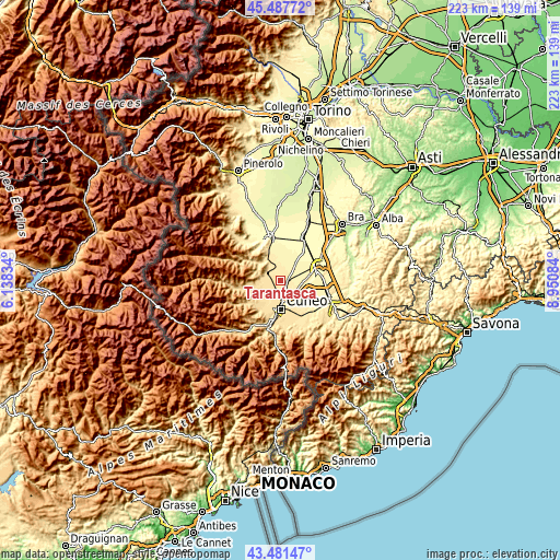
| \ | Map #1 | Topo.Map |
| Scale [m] | 406..496 m | × |
| Scale [ft] | 1332..1627 ft | × |
| Average | 453.3 m = 1487 ft | × |
| Width | 6.97 km = 4.3 mi | 223.1 km = 138.6 mi |
| Height | 6.97 km = 4.3 mi | 223.1 km = 138.6 mi |
| ↑Max Latitude | 44.524559° | 45.48772° |
| Latitude at center | 44.49322° | 44.49322° |
| ↓Min Latitude | 44.461864° | 43.48147° |
| ← Min Longitude | 7.500645° | 6.13834° |
| Longitude center | 7.54459° | 7.54459° |
| →Max Longitude | 7.588535° | 8.95084° |
Nearby cities:
Cities around Tarantasca sort by population:
• Cuneo elevation 546 m
11.4 km,  178°
178°
• Busca 499 m
6 km,  295°
295°
• Verzuolo 431 m
12.1 km,  335°
335°
• Centallo 425 m
3.6 km,  74°
74°
• Costiglione Saluzzo 457 m
9.2 km,  329°
329°
• Piasco 496 m
11 km,  313°
313°
• Villafalletto 431 m
5.9 km,  356°
356°
• Roata Rossi 491 m
5.7 km,  195°
195°
• Castelletto Stura 445 m
9.3 km,  126°
126°
• Rossana 524 m
10.6 km, 302°
• Montanera 422 m
10.2 km,  109°
109°
• Vottignasco 388 m
8.3 km,  19°
19°
Multilingual:
 En español:
Tarantasca elevación 453 m.
 En France:
Tarantasca élévation 453 m.
 Auf Deutsch:
Tarantasca höhe über dem Meeresspiegel ist 453 m.

Sources and notes:
- [note 1] Map square and city borders are not equal. Map elevation data is calculated only from area inside that square.
- [src 1] Elevation data from geonames database provided with same terms of usage.
- [src 2] The elevation map of Tarantasca is generated using elevation data from NASA's 3 arcsec (90m) resolution SRTM data.
- [src 3] Base (background) map © OpenStreetMap contributors tiles are generated by Geofabrik and OpenTopoMap.
Copyright & License:
This Tarantasca Elevation Map is licensed under CC BY-SA. You may reuse any part from this page, if you give a proper credit by linking to this URL:
 More info on terms of use page.