Terlano elevation
Terlano (Trentino-Alto Adige, Bolzano), Italy elevation is 252 meters and Terlano elevation in feet is 827 ft above sea level [src 1]. Terlano is a seat of a third-order administrative division (feature code) with elevation that is 70 meters (230 ft) smaller than average city elevation in Italy.
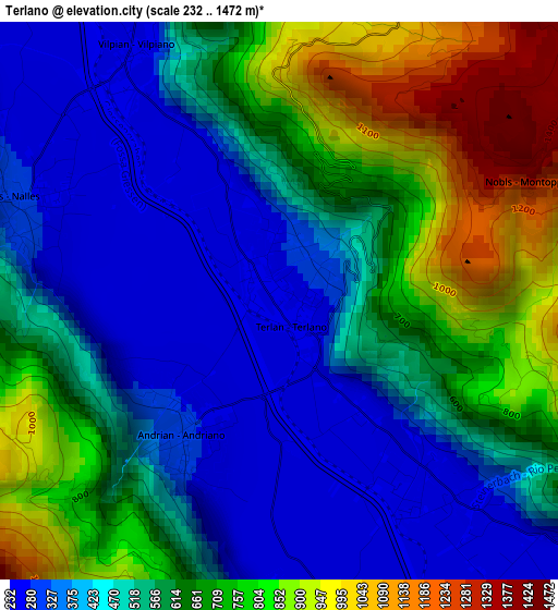
Below is the Elevation map of Terlano, which displays elevation range with different colors. Scale of the first map is from 232 to 1472 m (761 to 4829 ft) with average elevation of 566.4 meters (=1858 ft) [note 1]
These maps also provides idea of topography and contour of this city, they are displayed at different zoom levels. More info about maps, scale and edge coordinates you can find below images.
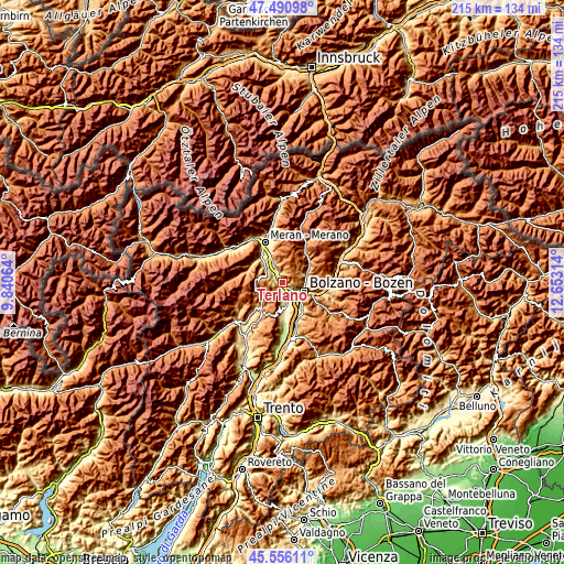
| \ | Map #1 | Topo.Map |
| Scale [m] | 232..1472 m | × |
| Scale [ft] | 761..4829 ft | × |
| Average | 566.4 m = 1858 ft | × |
| Width | 6.72 km = 4.2 mi | 215.1 km = 133.7 mi |
| Height | 6.72 km = 4.2 mi | 215.1 km = 133.7 mi |
| ↑Max Latitude | 46.562384° | 47.49098° |
| Latitude at center | 46.53216° | 46.53216° |
| ↓Min Latitude | 46.50192° | 45.55611° |
| ← Min Longitude | 11.202945° | 9.84064° |
| Longitude center | 11.24689° | 11.24689° |
| →Max Longitude | 11.290835° | 12.65314° |
Nearby cities:
Cities around Terlano sort by population:
• Bolzano elevation 257 m
8.5 km,  122°
122°
• San Michele 407 m
8.7 km,  172°
172°
• Nalles 288 m
3.4 km,  291°
291°
• Cornaiano 439 m
8.1 km,  161°
161°
• San Paolo 400 m
6.8 km, 171°
• Gargazzone 266 m
6.8 km,  329°
329°
• San Genesio Atesino 1079 m
6.3 km,  87°
87°
• Andriano 291 m
2 km,  216°
216°
• Verano - Voeran 1202 m
8.2 km,  348°
348°
• Tesimo 636 m
7 km,  301°
301°
• Verano 1191 m
8.2 km, 348°
• Meltina 1142 m
6.2 km,  5°
5°
Multilingual:
 En español:
Terlano elevación 252 m.
 En France:
Terlano élévation 252 m.


Sources and notes:
- [note 1] Map square and city borders are not equal. Map elevation data is calculated only from area inside that square.
- [src 1] Elevation data from geonames database provided with same terms of usage.
- [src 2] The elevation map of Terlano is generated using elevation data from NASA's 3 arcsec (90m) resolution SRTM data.
- [src 3] Base (background) map © OpenStreetMap contributors tiles are generated by Geofabrik and OpenTopoMap.
Copyright & License:
This Terlano Elevation Map is licensed under CC BY-SA. You may reuse any part from this page, if you give a proper credit by linking to this URL:
 More info on terms of use page.