Terrossa elevation
Terrossa (Veneto, Provincia di Verona), Italy elevation is 49 meters and Terrossa elevation in feet is 161 ft above sea level [src 1]. Terrossa is a populated place (feature code) with elevation that is 273 meters (896 ft) smaller than average city elevation in Italy.
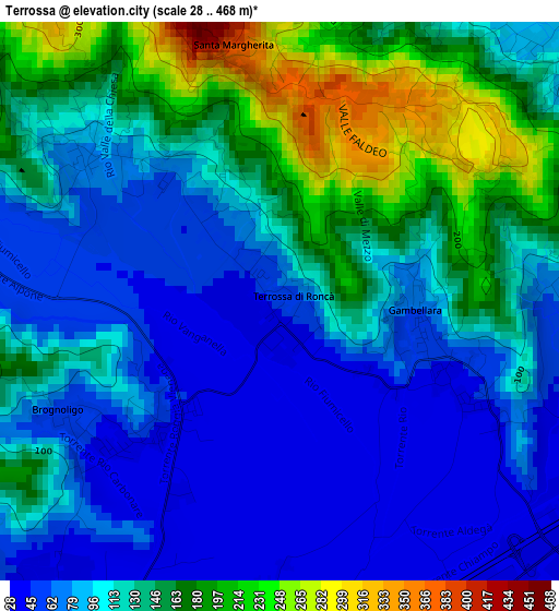
Below is the Elevation map of Terrossa, which displays elevation range with different colors. Scale of the first map is from 28 to 468 m (92 to 1535 ft) with average elevation of 115.9 meters (=380 ft) [note 1]
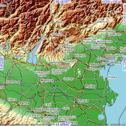
These maps also provides idea of topography and contour of this city, they are displayed at different zoom levels. More info about maps, scale and edge coordinates you can find below images.
| \ | Map #1 | Topo.Map |
| Scale [m] | 28..468 m | × |
| Scale [ft] | 92..1535 ft | × |
| Average | 115.9 m = 380 ft | × |
| Width | 6.85 km = 4.3 mi | 219.3 km = 136.3 mi |
| Height | 6.85 km = 4.3 mi | 219.3 km = 136.3 mi |
| ↑Max Latitude | 45.494213° | 46.44107° |
| Latitude at center | 45.4634° | 45.4634° |
| ↓Min Latitude | 45.43257° | 44.46848° |
| ← Min Longitude | 11.274655° | 9.91235° |
| Longitude center | 11.3186° | 11.3186° |
| →Max Longitude | 11.362545° | 12.72485° |
Nearby cities:
Cities around Terrossa sort by population:
• Arzignano elevation 117 m
6.4 km,  11°
11°
• Monteforte d'Alpone 33 m
5.5 km,  208°
208°
• Montebello Vicentino 83 m
5 km,  95°
95°
• Soave 31 m
7.5 km,  229°
229°
• Brognoligo-Costalunga 42 m
2.5 km, 229°
• Gambellara 55 m
1.7 km, 103°
• Montecchia di Crosara 80 m
5.4 km,  292°
292°
• Montorso Vicentino 86 m
4.5 km,  46°
46°
• Locara 29 m
5.8 km,  169°
169°
• Monticello di Fara 38 m
6.8 km,  124°
124°
• Roncà 75 m
2.7 km,  312°
312°
• Zermeghedo 62 m
4.6 km,  72°
72°
Multilingual:
 En español:
Terrossa elevación 49 m.
 En France:
Terrossa élévation 49 m.


Sources and notes:
- [note 1] Map square and city borders are not equal. Map elevation data is calculated only from area inside that square.
- [src 1] Elevation data from geonames database provided with same terms of usage.
- [src 2] The elevation map of Terrossa is generated using elevation data from NASA's 3 arcsec (90m) resolution SRTM data.
- [src 3] Base (background) map © OpenStreetMap contributors tiles are generated by Geofabrik and OpenTopoMap.
Copyright & License:
This Terrossa Elevation Map is licensed under CC BY-SA. You may reuse any part from this page, if you give a proper credit by linking to this URL:
 More info on terms of use page.