Torrebruna elevation
Torrebruna (Abruzzo, Provincia di Chieti), Italy elevation is 846 meters and Torrebruna elevation in feet is 2776 ft above sea level [src 1]. Torrebruna is a seat of a third-order administrative division (feature code) with elevation that is 524 meters (1719 ft) bigger than average city elevation in Italy.
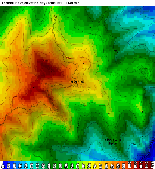
Below is the Elevation map of Torrebruna, which displays elevation range with different colors. Scale of the first map is from 191 to 1149 m (627 to 3770 ft) with average elevation of 652.2 meters (=2140 ft) [note 1]
These maps also provides idea of topography and contour of this city, they are displayed at different zoom levels. More info about maps, scale and edge coordinates you can find below images.
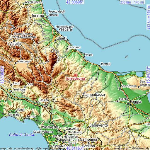
| \ | Map #1 | Topo.Map |
| Scale [m] | 191..1149 m | × |
| Scale [ft] | 627..3770 ft | × |
| Average | 652.2 m = 2140 ft | × |
| Width | 7.28 km = 4.5 mi | 232.9 km = 144.7 mi |
| Height | 7.28 km = 4.5 mi | 232.9 km = 144.7 mi |
| ↑Max Latitude | 41.900137° | 42.90605° |
| Latitude at center | 41.86742° | 41.86742° |
| ↓Min Latitude | 41.834686° | 40.81163° |
| ← Min Longitude | 14.497535° | 13.13523° |
| Longitude center | 14.54148° | 14.54148° |
| →Max Longitude | 14.585425° | 15.94773° |
Nearby cities:
Cities around Torrebruna sort by population:
• Castiglione Messer Marino elevation 1066 m
7.6 km,  270°
270°
• Montefalcone nel Sannio 607 m
8 km,  90°
90°
• Celenza sul Trigno 603 m
3.1 km,  80°
80°
• Roccavivara 680 m
6.2 km,  127°
127°
• Palmoli 703 m
8.7 km,  22°
22°
• Carunchio 624 m
5.7 km,  347°
347°
• Tufillo 556 m
8.9 km,  51°
51°
• Montemitro 483 m
9 km, 75°
• Fraine 723 m
6.2 km,  314°
314°
• Castelguidone 769 m
5.2 km,  197°
197°
• Schiavi di Abruzzo 1135 m
7.6 km,  216°
216°
• San Giovanni Lipioni 532 m
3.2 km,  146°
146°
Multilingual:
 En español:
Torrebruna elevación 846 m.
 En France:
Torrebruna élévation 846 m.
 Auf Deutsch:
Torrebruna höhe über dem Meeresspiegel ist 846 m.

Sources and notes:
- [note 1] Map square and city borders are not equal. Map elevation data is calculated only from area inside that square.
- [src 1] Elevation data from geonames database provided with same terms of usage.
- [src 2] The elevation map of Torrebruna is generated using elevation data from NASA's 3 arcsec (90m) resolution SRTM data.
- [src 3] Base (background) map © OpenStreetMap contributors tiles are generated by Geofabrik and OpenTopoMap.
Copyright & License:
This Torrebruna Elevation Map is licensed under CC BY-SA. You may reuse any part from this page, if you give a proper credit by linking to this URL:
 More info on terms of use page.