Travesio elevation
Travesio (Friuli Venezia Giulia, Provincia di Pordenone), Italy elevation is 219 meters and Travesio elevation in feet is 719 ft above sea level [src 1]. Travesio is a seat of a third-order administrative division (feature code) with elevation that is 103 meters (338 ft) smaller than average city elevation in Italy.
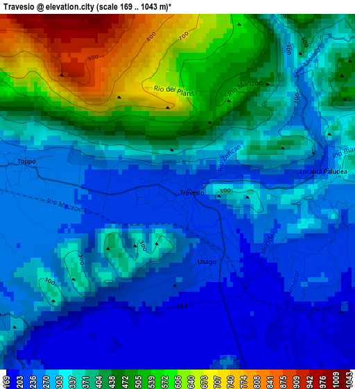
Below is the Elevation map of Travesio, which displays elevation range with different colors. Scale of the first map is from 169 to 1043 m (554 to 3422 ft) with average elevation of 355.1 meters (=1165 ft) [note 1]
These maps also provides idea of topography and contour of this city, they are displayed at different zoom levels. More info about maps, scale and edge coordinates you can find below images.
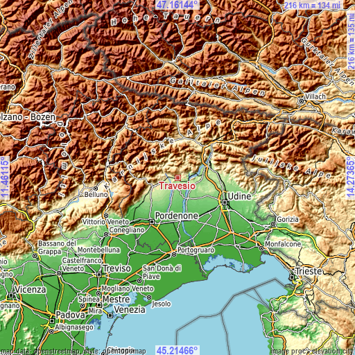
| \ | Map #1 | Topo.Map |
| Scale [m] | 169..1043 m | × |
| Scale [ft] | 554..3422 ft | × |
| Average | 355.1 m = 1165 ft | × |
| Width | 6.76 km = 4.2 mi | 216.5 km = 134.5 mi |
| Height | 6.76 km = 4.2 mi | 216.4 km = 134.5 mi |
| ↑Max Latitude | 46.22708° | 47.16144° |
| Latitude at center | 46.19667° | 46.19667° |
| ↓Min Latitude | 46.166243° | 45.21466° |
| ← Min Longitude | 12.823455° | 11.46115° |
| Longitude center | 12.8674° | 12.8674° |
| →Max Longitude | 12.911345° | 14.27365° |
Nearby cities:
Cities around Travesio sort by population:
• San Giacomo elevation 226 m
9.3 km,  106°
106°
• Fanna 263 m
9 km,  261°
261°
• Cavasso Nuovo 274 m
7.4 km,  268°
268°
• Meduno 284 m
5.6 km,  291°
291°
• Lestans 174 m
4.6 km,  159°
159°
• Arba 210 m
8.2 km,  226°
226°
• Sequals 210 m
4.6 km,  217°
217°
• Forgaria nel Friuli 250 m
8.7 km,  72°
72°
• Pinzano al Tagliamento 203 m
6.1 km, 105°
• Anduins 317 m
8.1 km,  59°
59°
• Paludea 240 m
2.8 km,  83°
83°
• Clauzetto 554 m
5.2 km,  46°
46°
Multilingual:
 En español:
Travesio elevación 219 m.
 En France:
Travesio élévation 219 m.
 Auf Deutsch:
Travesio höhe über dem Meeresspiegel ist 219 m.

Sources and notes:
- [note 1] Map square and city borders are not equal. Map elevation data is calculated only from area inside that square.
- [src 1] Elevation data from geonames database provided with same terms of usage.
- [src 2] The elevation map of Travesio is generated using elevation data from NASA's 3 arcsec (90m) resolution SRTM data.
- [src 3] Base (background) map © OpenStreetMap contributors tiles are generated by Geofabrik and OpenTopoMap.
Copyright & License:
This Travesio Elevation Map is licensed under CC BY-SA. You may reuse any part from this page, if you give a proper credit by linking to this URL:
 More info on terms of use page.