Trinità elevation
Trinità (Piedmont, Provincia di Cuneo), Italy elevation is 372 meters and Trinità elevation in feet is 1220 ft above sea level [src 1]. Trinità is a seat of a third-order administrative division (feature code) with elevation that is 50 meters (164 ft) bigger than average city elevation in Italy.
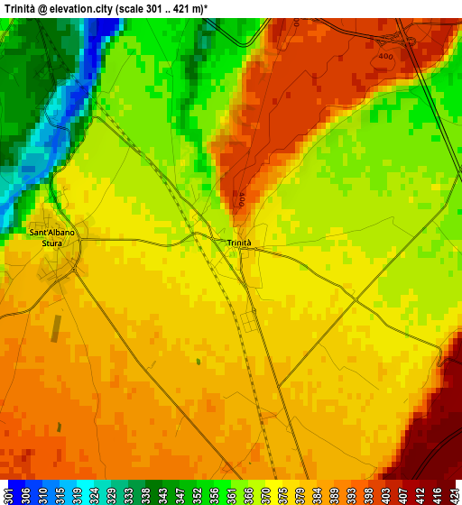
Below is the Elevation map of Trinità, which displays elevation range with different colors. Scale of the first map is from 301 to 421 m (988 to 1381 ft) with average elevation of 375 meters (=1230 ft) [note 1]
These maps also provides idea of topography and contour of this city, they are displayed at different zoom levels. More info about maps, scale and edge coordinates you can find below images.
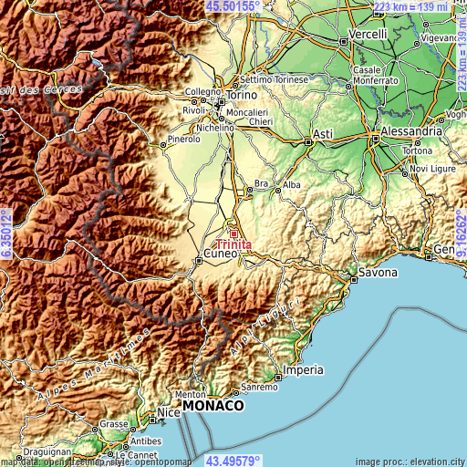
| \ | Map #1 | Topo.Map |
| Scale [m] | 301..421 m | × |
| Scale [ft] | 988..1381 ft | × |
| Average | 375 m = 1230 ft | × |
| Width | 6.97 km = 4.3 mi | 223 km = 138.6 mi |
| Height | 6.97 km = 4.3 mi | 223 km = 138.6 mi |
| ↑Max Latitude | 44.538632° | 45.50155° |
| Latitude at center | 44.5073° | 44.5073° |
| ↓Min Latitude | 44.475951° | 43.49579° |
| ← Min Longitude | 7.712425° | 6.35012° |
| Longitude center | 7.75637° | 7.75637° |
| →Max Longitude | 7.800315° | 9.16262° |
Nearby cities:
Cities around Trinità sort by population:
• Fossano elevation 357 m
5.7 km,  328°
328°
• Carrù 363 m
9.7 km,  108°
108°
• Bene Vagienna 352 m
6.9 km,  55°
55°
• Magliano Alpi 382 m
7.4 km,  137°
137°
• Sant'Albano Stura 380 m
2.7 km,  270°
270°
• Morozzo 432 m
10.1 km,  201°
201°
• Crava 415 m
8.6 km,  186°
186°
• Montanera 422 m
8.8 km,  235°
235°
• Piozzo 329 m
10.8 km,  86°
86°
• Lequio Tanaro 329 m
11.6 km, 59°
• Salmour 389 m
8.1 km,  20°
20°
• Rocca De' Baldi 414 m
9.3 km,  177°
177°
Multilingual:
 En español:
Trinità elevación 372 m.
 En France:
Trinità élévation 372 m.


Sources and notes:
- [note 1] Map square and city borders are not equal. Map elevation data is calculated only from area inside that square.
- [src 1] Elevation data from geonames database provided with same terms of usage.
- [src 2] The elevation map of Trinità is generated using elevation data from NASA's 3 arcsec (90m) resolution SRTM data.
- [src 3] Base (background) map © OpenStreetMap contributors tiles are generated by Geofabrik and OpenTopoMap.
Copyright & License:
This Trinità Elevation Map is licensed under CC BY-SA. You may reuse any part from this page, if you give a proper credit by linking to this URL:
 More info on terms of use page.