Morozzo elevation
Morozzo (Piedmont, Provincia di Cuneo), Italy elevation is 432 meters and Morozzo elevation in feet is 1417 ft above sea level [src 1]. Morozzo is a seat of a third-order administrative division (feature code) with elevation that is 110 meters (361 ft) bigger than average city elevation in Italy.
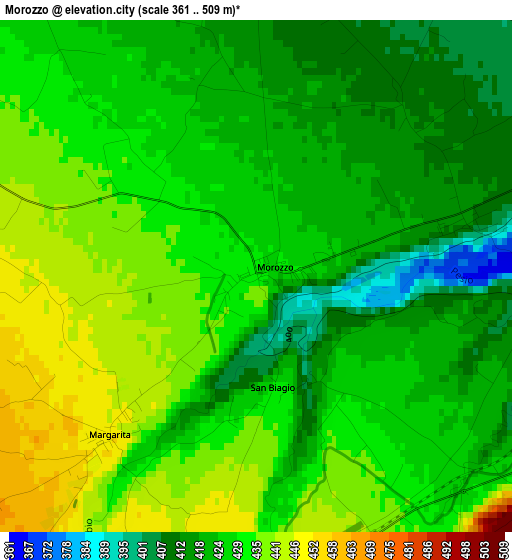
Below is the Elevation map of Morozzo, which displays elevation range with different colors. Scale of the first map is from 361 to 509 m (1184 to 1670 ft) with average elevation of 426.9 meters (=1401 ft) [note 1]
These maps also provides idea of topography and contour of this city, they are displayed at different zoom levels. More info about maps, scale and edge coordinates you can find below images.
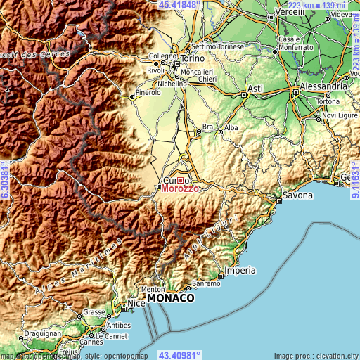
| \ | Map #1 | Topo.Map |
| Scale [m] | 361..509 m | × |
| Scale [ft] | 1184..1670 ft | × |
| Average | 426.9 m = 1401 ft | × |
| Width | 6.98 km = 4.3 mi | 223.3 km = 138.8 mi |
| Height | 6.98 km = 4.3 mi | 223.3 km = 138.8 mi |
| ↑Max Latitude | 44.454147° | 45.41848° |
| Latitude at center | 44.42277° | 44.42277° |
| ↓Min Latitude | 44.391376° | 43.40981° |
| ← Min Longitude | 7.666115° | 6.30381° |
| Longitude center | 7.71006° | 7.71006° |
| →Max Longitude | 7.754005° | 9.11631° |
Nearby cities:
Cities around Morozzo sort by population:
• Mondovì elevation 418 m
9 km,  109°
109°
• Breo 413 m
9.1 km, 107°
• Villanova Mondovì 529 m
9.5 km,  151°
151°
• Beinette 488 m
8.4 km,  218°
218°
• Magliano Alpi 382 m
9.5 km,  65°
65°
• Sant'Albano Stura 380 m
9.5 km,  6°
6°
• Pianfei 499 m
5.6 km,  178°
178°
• Margarita 449 m
2.9 km, 222°
• Castelletto Stura 445 m
6.1 km,  292°
292°
• Crava 415 m
2.9 km, 73°
• Montanera 422 m
5.6 km,  321°
321°
• Rocca De' Baldi 414 m
4.1 km,  88°
88°
Multilingual:
 En español:
Morozzo elevación 432 m.
 En France:
Morozzo élévation 432 m.


Sources and notes:
- [note 1] Map square and city borders are not equal. Map elevation data is calculated only from area inside that square.
- [src 1] Elevation data from geonames database provided with same terms of usage.
- [src 2] The elevation map of Morozzo is generated using elevation data from NASA's 3 arcsec (90m) resolution SRTM data.
- [src 3] Base (background) map © OpenStreetMap contributors tiles are generated by Geofabrik and OpenTopoMap.
Copyright & License:
This Morozzo Elevation Map is licensed under CC BY-SA. You may reuse any part from this page, if you give a proper credit by linking to this URL:
 More info on terms of use page.