Trodena elevation
Trodena (Trentino-Alto Adige, Bolzano), Italy elevation is 1130 meters and Trodena elevation in feet is 3707 ft above sea level [src 1]. Trodena is a seat of a third-order administrative division (feature code) with elevation that is 808 meters (2651 ft) bigger than average city elevation in Italy.
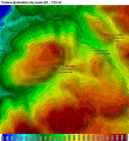
Below is the Elevation map of Trodena, which displays elevation range with different colors. Scale of the first map is from 229 to 1723 m (751 to 5653 ft) with average elevation of 1144 meters (=3753 ft) [note 1]
These maps also provides idea of topography and contour of this city, they are displayed at different zoom levels. More info about maps, scale and edge coordinates you can find below images.
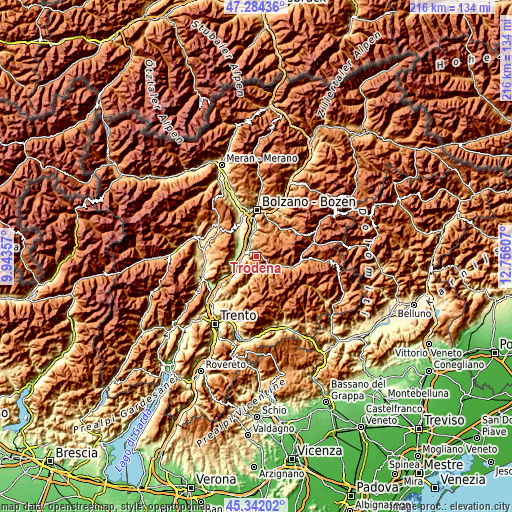
| \ | Map #1 | Topo.Map |
| Scale [m] | 229..1723 m | × |
| Scale [ft] | 751..5653 ft | × |
| Average | 1144 m = 3753 ft | × |
| Width | 6.75 km = 4.2 mi | 216 km = 134.2 mi |
| Height | 6.75 km = 4.2 mi | 216 km = 134.2 mi |
| ↑Max Latitude | 46.352151° | 47.28436° |
| Latitude at center | 46.32181° | 46.32181° |
| ↓Min Latitude | 46.291453° | 45.34202° |
| ← Min Longitude | 11.305875° | 9.94357° |
| Longitude center | 11.34982° | 11.34982° |
| →Max Longitude | 11.393765° | 12.75607° |
Nearby cities:
Cities around Trodena sort by population:
• Egna elevation 224 m
5.9 km,  265°
265°
• Ora 249 m
4.9 km,  304°
304°
• Termeno 260 m
8.5 km,  284°
284°
• Aldino 1191 m
4.9 km,  4°
4°
• Castello Molina di Fiemme 970 m
7.8 km,  124°
124°
• Montagna 438 m
3.9 km, 283°
• Carano 1078 m
7.7 km, 115°
• Varena 1208 m
8.5 km,  101°
101°
• Daiano 1196 m
7.9 km,  106°
106°
• Valfloriana 845 m
8 km,  183°
183°
• Capriana 1002 m
6.6 km,  187°
187°
• Anterivo 1221 m
5 km,  165°
165°
Multilingual:
 En español:
Trodena elevación 1130 m.
 En France:
Trodena élévation 1130 m.
 Auf Deutsch:
Truden im Naturpark höhe über dem Meeresspiegel ist 1130 m.

Sources and notes:
- [note 1] Map square and city borders are not equal. Map elevation data is calculated only from area inside that square.
- [src 1] Elevation data from geonames database provided with same terms of usage.
- [src 2] The elevation map of Trodena is generated using elevation data from NASA's 3 arcsec (90m) resolution SRTM data.
- [src 3] Base (background) map © OpenStreetMap contributors tiles are generated by Geofabrik and OpenTopoMap.
Copyright & License:
This Trodena Elevation Map is licensed under CC BY-SA. You may reuse any part from this page, if you give a proper credit by linking to this URL:
 More info on terms of use page.