Urbisaglia elevation
Urbisaglia (The Marches, Provincia di Macerata), Italy elevation is 311 meters and Urbisaglia elevation in feet is 1020 ft above sea level [src 1]. Urbisaglia is a seat of a third-order administrative division (feature code) with elevation that is 11 meters (36 ft) smaller than average city elevation in Italy.
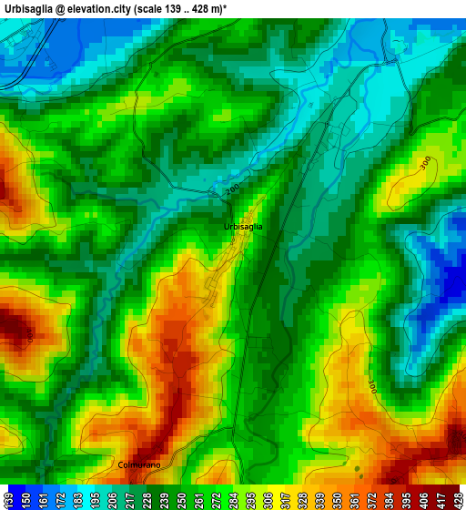
Below is the Elevation map of Urbisaglia, which displays elevation range with different colors. Scale of the first map is from 139 to 428 m (456 to 1404 ft) with average elevation of 259.3 meters (=851 ft) [note 1]
These maps also provides idea of topography and contour of this city, they are displayed at different zoom levels. More info about maps, scale and edge coordinates you can find below images.
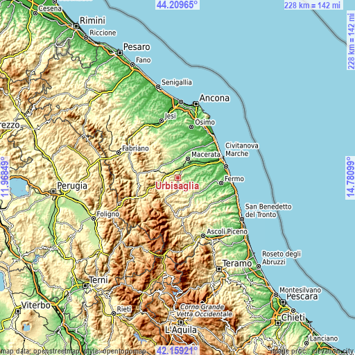
| \ | Map #1 | Topo.Map |
| Scale [m] | 139..428 m | × |
| Scale [ft] | 456..1404 ft | × |
| Average | 259.3 m = 851 ft | × |
| Width | 7.12 km = 4.4 mi | 228 km = 141.7 mi |
| Height | 7.12 km = 4.4 mi | 228 km = 141.7 mi |
| ↑Max Latitude | 43.22507° | 44.20965° |
| Latitude at center | 43.19304° | 43.19304° |
| ↓Min Latitude | 43.160993° | 42.15921° |
| ← Min Longitude | 13.330795° | 11.96849° |
| Longitude center | 13.37474° | 13.37474° |
| →Max Longitude | 13.418685° | 14.78099° |
Nearby cities:
Cities around Urbisaglia sort by population:
• Tolentino elevation 231 m
7.5 km,  283°
283°
• Mogliano 253 m
9.5 km,  93°
93°
• Sforzacosta 133 m
8.1 km,  28°
28°
• Pollenza 339 m
8.4 km,  344°
344°
• Casette Verdini 150 m
6.8 km,  18°
18°
• Montappone 324 m
9.9 km,  129°
129°
• Loro Piceno 409 m
4.4 km,  136°
136°
• Petriolo 246 m
7.7 km,  65°
65°
• San Ginesio 664 m
10.5 km,  204°
204°
• Colmurano 406 m
3.4 km, 202°
• Massa Fermana 288 m
9.7 km,  121°
121°
• Ripe San Ginesio 421 m
5.7 km,  186°
186°
Multilingual:
 En español:
Urbisaglia elevación 311 m.
 En France:
Urbisaglia élévation 311 m.
 Auf Deutsch:
Urbisaglia höhe über dem Meeresspiegel ist 311 m.

Sources and notes:
- [note 1] Map square and city borders are not equal. Map elevation data is calculated only from area inside that square.
- [src 1] Elevation data from geonames database provided with same terms of usage.
- [src 2] The elevation map of Urbisaglia is generated using elevation data from NASA's 3 arcsec (90m) resolution SRTM data.
- [src 3] Base (background) map © OpenStreetMap contributors tiles are generated by Geofabrik and OpenTopoMap.
Copyright & License:
This Urbisaglia Elevation Map is licensed under CC BY-SA. You may reuse any part from this page, if you give a proper credit by linking to this URL:
 More info on terms of use page.