Massa Fermana elevation
Massa Fermana (The Marches, Province of Fermo), Italy elevation is 288 meters and Massa Fermana elevation in feet is 945 ft above sea level [src 1]. Massa Fermana is a seat of a third-order administrative division (feature code) with elevation that is 34 meters (112 ft) smaller than average city elevation in Italy.
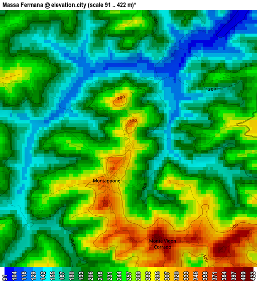
Below is the Elevation map of Massa Fermana, which displays elevation range with different colors. Scale of the first map is from 91 to 422 m (299 to 1385 ft) with average elevation of 216.6 meters (=711 ft) [note 1]
These maps also provides idea of topography and contour of this city, they are displayed at different zoom levels. More info about maps, scale and edge coordinates you can find below images.
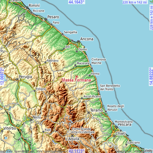
| \ | Map #1 | Topo.Map |
| Scale [m] | 91..422 m | × |
| Scale [ft] | 299..1385 ft | × |
| Average | 216.6 m = 711 ft | × |
| Width | 7.13 km = 4.4 mi | 228.2 km = 141.8 mi |
| Height | 7.13 km = 4.4 mi | 228.2 km = 141.8 mi |
| ↑Max Latitude | 43.178964° | 44.1643° |
| Latitude at center | 43.14691° | 43.14691° |
| ↓Min Latitude | 43.114839° | 42.1123° |
| ← Min Longitude | 13.432025° | 12.06972° |
| Longitude center | 13.47597° | 13.47597° |
| →Max Longitude | 13.519915° | 14.88222° |
Nearby cities:
Cities around Massa Fermana sort by population:
• Mogliano elevation 253 m
4.7 km,  15°
15°
• Montegiorgio 369 m
5.5 km,  110°
110°
• Piane di Montegiorgio 158 m
8.1 km,  115°
115°
• Montappone 324 m
1.3 km,  204°
204°
• Piane 215 m
5.8 km,  164°
164°
• Servigliano 219 m
7.6 km,  169°
169°
• Loro Piceno 409 m
5.6 km,  290°
290°
• Francavilla d'Ete 183 m
7 km,  48°
48°
• Falerone 374 m
4.8 km,  183°
183°
• Sant'Angelo in Pontano 455 m
8.4 km,  229°
229°
• Monte Vidon Corrado 393 m
3.1 km, 159°
• Belmonte Piceno 296 m
8 km,  139°
139°
Multilingual:
 En español:
Massa Fermana elevación 288 m.
 En France:
Massa Fermana élévation 288 m.
 Auf Deutsch:
Massa Fermana höhe über dem Meeresspiegel ist 288 m.

Sources and notes:
- [note 1] Map square and city borders are not equal. Map elevation data is calculated only from area inside that square.
- [src 1] Elevation data from geonames database provided with same terms of usage.
- [src 2] The elevation map of Massa Fermana is generated using elevation data from NASA's 3 arcsec (90m) resolution SRTM data.
- [src 3] Base (background) map © OpenStreetMap contributors tiles are generated by Geofabrik and OpenTopoMap.
Copyright & License:
This Massa Fermana Elevation Map is licensed under CC BY-SA. You may reuse any part from this page, if you give a proper credit by linking to this URL:
 More info on terms of use page.