Valdottavo elevation
Valdottavo (Tuscany, Provincia di Lucca), Italy elevation is 82 meters and Valdottavo elevation in feet is 269 ft above sea level [src 1]. Valdottavo is a populated place (feature code) with elevation that is 240 meters (787 ft) smaller than average city elevation in Italy.
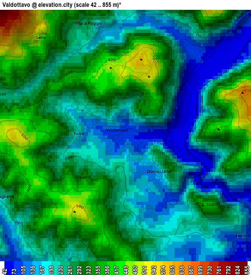
Below is the Elevation map of Valdottavo, which displays elevation range with different colors. Scale of the first map is from 42 to 855 m (138 to 2805 ft) with average elevation of 264.9 meters (=869 ft) [note 1]
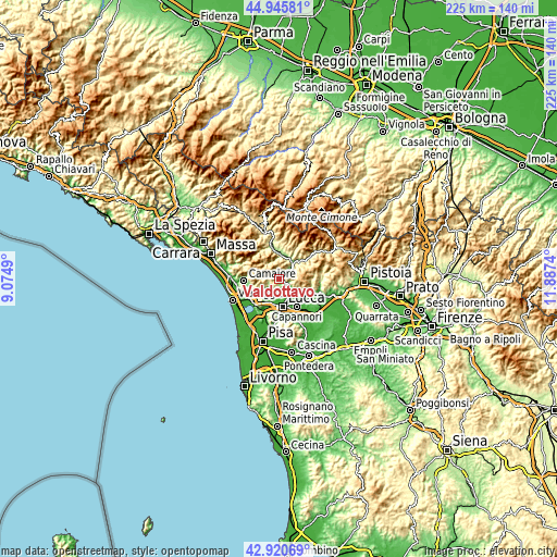
These maps also provides idea of topography and contour of this city, they are displayed at different zoom levels. More info about maps, scale and edge coordinates you can find below images.
| \ | Map #1 | Topo.Map |
| Scale [m] | 42..855 m | × |
| Scale [ft] | 138..2805 ft | × |
| Average | 264.9 m = 869 ft | × |
| Width | 7.04 km = 4.4 mi | 225.2 km = 139.9 mi |
| Height | 7.04 km = 4.4 mi | 225.2 km = 139.9 mi |
| ↑Max Latitude | 43.973504° | 44.94581° |
| Latitude at center | 43.94187° | 43.94187° |
| ↓Min Latitude | 43.910219° | 42.92069° |
| ← Min Longitude | 10.437205° | 9.0749° |
| Longitude center | 10.48115° | 10.48115° |
| →Max Longitude | 10.525095° | 11.8874° |
Nearby cities:
Cities around Valdottavo sort by population:
• Lucca elevation 29 m
11.1 km,  170°
170°
• Capannori 15 m
13.3 km,  146°
146°
• Massarosa 13 m
13.8 km,  232°
232°
• Piano di Coreglia-Ghivizzano 206 m
10.6 km,  15°
15°
• Bagni di Lucca 124 m
9.1 km,  39°
39°
• Gallicano 181 m
13.3 km,  346°
346°
• Fornaci di Barga 165 m
11.9 km,  356°
356°
• Borgo a Mozzano 108 m
6.6 km,  50°
50°
• San Martino in Freddana-Monsagrati 80 m
5 km,  223°
223°
• Villa Basilica 335 m
13.3 km,  97°
97°
• Fabbriche di Vallico 367 m
7.5 km,  325°
325°
• Pescaglia 420 m
6 km,  295°
295°
Multilingual:
 En español:
Valdottavo elevación 82 m.
 En France:
Valdottavo élévation 82 m.
 Auf Deutsch:
Valdottavo höhe über dem Meeresspiegel ist 82 m.

Sources and notes:
- [note 1] Map square and city borders are not equal. Map elevation data is calculated only from area inside that square.
- [src 1] Elevation data from geonames database provided with same terms of usage.
- [src 2] The elevation map of Valdottavo is generated using elevation data from NASA's 3 arcsec (90m) resolution SRTM data.
- [src 3] Base (background) map © OpenStreetMap contributors tiles are generated by Geofabrik and OpenTopoMap.
Copyright & License:
This Valdottavo Elevation Map is licensed under CC BY-SA. You may reuse any part from this page, if you give a proper credit by linking to this URL:
 More info on terms of use page.