Gallicano elevation
Gallicano (Tuscany, Provincia di Lucca), Italy elevation is 181 meters and Gallicano elevation in feet is 594 ft above sea level [src 1]. Gallicano is a seat of a third-order administrative division (feature code) with elevation that is 141 meters (463 ft) smaller than average city elevation in Italy.
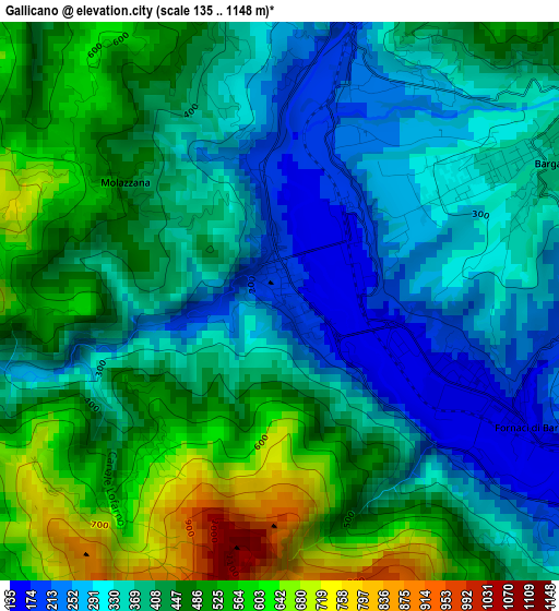
Below is the Elevation map of Gallicano, which displays elevation range with different colors. Scale of the first map is from 135 to 1148 m (443 to 3766 ft) with average elevation of 410.8 meters (=1348 ft) [note 1]
These maps also provides idea of topography and contour of this city, they are displayed at different zoom levels. More info about maps, scale and edge coordinates you can find below images.
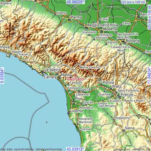
| \ | Map #1 | Topo.Map |
| Scale [m] | 135..1148 m | × |
| Scale [ft] | 443..3766 ft | × |
| Average | 410.8 m = 1348 ft | × |
| Width | 7.02 km = 4.4 mi | 224.7 km = 139.6 mi |
| Height | 7.02 km = 4.4 mi | 224.7 km = 139.6 mi |
| ↑Max Latitude | 44.089902° | 45.06028° |
| Latitude at center | 44.05833° | 44.05833° |
| ↓Min Latitude | 44.026741° | 43.03913° |
| ← Min Longitude | 10.398145° | 9.03584° |
| Longitude center | 10.44209° | 10.44209° |
| →Max Longitude | 10.486035° | 11.84834° |
Nearby cities:
Cities around Gallicano sort by population:
• Castelnuovo di Garfagnana elevation 274 m
6.7 km,  333°
333°
• Piano di Coreglia-Ghivizzano 206 m
6.6 km,  115°
115°
• Barga 347 m
3.3 km,  60°
60°
• Bagni di Lucca 124 m
10.7 km, 123°
• Fornaci di Barga 165 m
2.5 km,  114°
114°
• Pieve Fosciana 359 m
8.5 km,  342°
342°
• Coreglia Antelminelli 557 m
6.6 km,  85°
85°
• Castiglione di Garfagnana 570 m
10.7 km,  347°
347°
• Fabbriche di Vallico 367 m
6.8 km,  189°
189°
• Pescaglia 420 m
10.6 km, 192°
• Fosciandora 430 m
6.4 km,  11°
11°
• Molazzana 467 m
2.4 km,  307°
307°
Multilingual:
 En español:
Gallicano elevación 181 m.
 En France:
Gallicano élévation 181 m.
 Auf Deutsch:
Gallicano höhe über dem Meeresspiegel ist 181 m.

Sources and notes:
- [note 1] Map square and city borders are not equal. Map elevation data is calculated only from area inside that square.
- [src 1] Elevation data from geonames database provided with same terms of usage.
- [src 2] The elevation map of Gallicano is generated using elevation data from NASA's 3 arcsec (90m) resolution SRTM data.
- [src 3] Base (background) map © OpenStreetMap contributors tiles are generated by Geofabrik and OpenTopoMap.
Copyright & License:
This Gallicano Elevation Map is licensed under CC BY-SA. You may reuse any part from this page, if you give a proper credit by linking to this URL:
 More info on terms of use page.