Zuccarello elevation
Zuccarello (Liguria, Provincia di Savona), Italy elevation is 203 meters and Zuccarello elevation in feet is 666 ft above sea level [src 1]. Zuccarello is a seat of a third-order administrative division (feature code) with elevation that is 119 meters (390 ft) smaller than average city elevation in Italy.
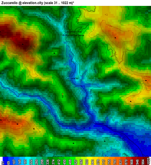
Below is the Elevation map of Zuccarello, which displays elevation range with different colors. Scale of the first map is from 31 to 1022 m (102 to 3353 ft) with average elevation of 418 meters (=1371 ft) [note 1]
These maps also provides idea of topography and contour of this city, they are displayed at different zoom levels. More info about maps, scale and edge coordinates you can find below images.
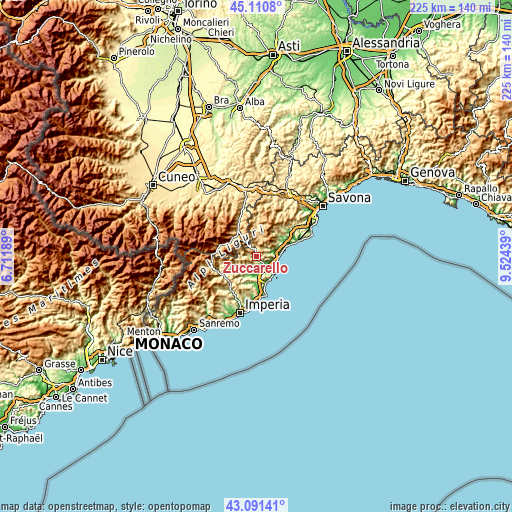
| \ | Map #1 | Topo.Map |
| Scale [m] | 31..1022 m | × |
| Scale [ft] | 102..3353 ft | × |
| Average | 418 m = 1371 ft | × |
| Width | 7.02 km = 4.4 mi | 224.5 km = 139.5 mi |
| Height | 7.02 km = 4.4 mi | 224.5 km = 139.5 mi |
| ↑Max Latitude | 44.141275° | 45.1108° |
| Latitude at center | 44.10973° | 44.10973° |
| ↓Min Latitude | 44.078168° | 43.09141° |
| ← Min Longitude | 8.074195° | 6.71189° |
| Longitude center | 8.11814° | 8.11814° |
| →Max Longitude | 8.162085° | 9.52439° |
Nearby cities:
Cities around Zuccarello sort by population:
• Villanova d'Albenga elevation 34 m
7.2 km,  163°
163°
• Ortovero 62 m
6.4 km,  193°
193°
• Cisano 54 m
3.6 km,  138°
138°
• Arnasco 293 m
3.6 km, 193°
• Vendone 360 m
5.2 km,  225°
225°
• Balestrino 365 m
4.5 km,  68°
68°
• Castelbianco 373 m
3.5 km,  278°
278°
• Onzo 433 m
6.9 km, 230°
• Chiesa 264 m
3.6 km, 191°
• Erli 326 m
3.2 km,  340°
340°
• Nasino-Borgo 304 m
6.9 km,  273°
273°
• Castelvecchio di Rocca Barbena 407 m
2.2 km,  356°
356°
Multilingual:
 En español:
Zuccarello elevación 203 m.
 En France:
Zuccarello élévation 203 m.
 Auf Deutsch:
Zuccarello höhe über dem Meeresspiegel ist 203 m.

Sources and notes:
- [note 1] Map square and city borders are not equal. Map elevation data is calculated only from area inside that square.
- [src 1] Elevation data from geonames database provided with same terms of usage.
- [src 2] The elevation map of Zuccarello is generated using elevation data from NASA's 3 arcsec (90m) resolution SRTM data.
- [src 3] Base (background) map © OpenStreetMap contributors tiles are generated by Geofabrik and OpenTopoMap.
Copyright & License:
This Zuccarello Elevation Map is licensed under CC BY-SA. You may reuse any part from this page, if you give a proper credit by linking to this URL:
 More info on terms of use page.