Acquappesa elevation
Acquappesa (Calabria, Provincia di Cosenza), Italy elevation is 100 meters and Acquappesa elevation in feet is 328 ft above sea level [src 1]. Acquappesa is a seat of a third-order administrative division (feature code) with elevation that is 222 meters (728 ft) smaller than average city elevation in Italy.
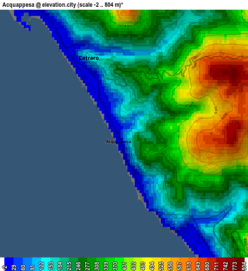
Below is the Elevation map of Acquappesa, which displays elevation range with different colors. Scale of the first map is from -2 to 804 m (-7 to 2638 ft) with average elevation of 291.8 meters (=957 ft) [note 1]
These maps also provides idea of topography and contour of this city, they are displayed at different zoom levels. More info about maps, scale and edge coordinates you can find below images.
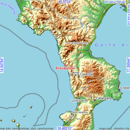
| \ | Map #1 | Topo.Map |
| Scale [m] | -2..804 m | × |
| Scale [ft] | -7..2638 ft | × |
| Average | 291.8 m = 957 ft | × |
| Width | 7.54 km = 4.7 mi | 241.3 km = 149.9 mi |
| Height | 7.54 km = 4.7 mi | 241.3 km = 149.9 mi |
| ↑Max Latitude | 39.529633° | 40.5724° |
| Latitude at center | 39.49573° | 39.49573° |
| ↓Min Latitude | 39.46181° | 38.40212° |
| ← Min Longitude | 15.910245° | 14.54794° |
| Longitude center | 15.95419° | 15.95419° |
| →Max Longitude | 15.998135° | 17.36044° |
Nearby cities:
Cities around Acquappesa sort by population:
• Cetraro Marina elevation 8 m
2.9 km,  324°
324°
• Fagnano Castello 478 m
12.5 km,  47°
47°
• Marina di Fuscaldo 21 m
9.2 km,  150°
150°
• Scarcelli 46 m
11.9 km, 153°
• Cetraro 138 m
2.6 km,  335°
335°
• Cittadella del Capo 32 m
9.7 km, 316°
• Marina 8 m
4.3 km, 147°
• Fuscaldo 283 m
11.1 km,  144°
144°
• Bonifati 427 m
11 km, 335°
• Sangineto 280 m
12.7 km, 344°
• San Martino di Finita 502 m
13.4 km,  92°
92°
• Guardia Piemontese 493 m
5.1 km,  130°
130°
Multilingual:
 En español:
Acquappesa elevación 100 m.
 En France:
Acquappesa élévation 100 m.
 Auf Deutsch:
Acquappesa höhe über dem Meeresspiegel ist 100 m.

Sources and notes:
- [note 1] Map square and city borders are not equal. Map elevation data is calculated only from area inside that square.
- [src 1] Elevation data from geonames database provided with same terms of usage.
- [src 2] The elevation map of Acquappesa is generated using elevation data from NASA's 3 arcsec (90m) resolution SRTM data.
- [src 3] Base (background) map © OpenStreetMap contributors tiles are generated by Geofabrik and OpenTopoMap.
Copyright & License:
This Acquappesa Elevation Map is licensed under CC BY-SA. You may reuse any part from this page, if you give a proper credit by linking to this URL:
 More info on terms of use page.