Amantea elevation
Amantea (Calabria, Provincia di Cosenza), Italy elevation is 13 meters and Amantea elevation in feet is 43 ft above sea level [src 1]. Amantea is a seat of a third-order administrative division (feature code) with elevation that is 309 meters (1014 ft) smaller than average city elevation in Italy.
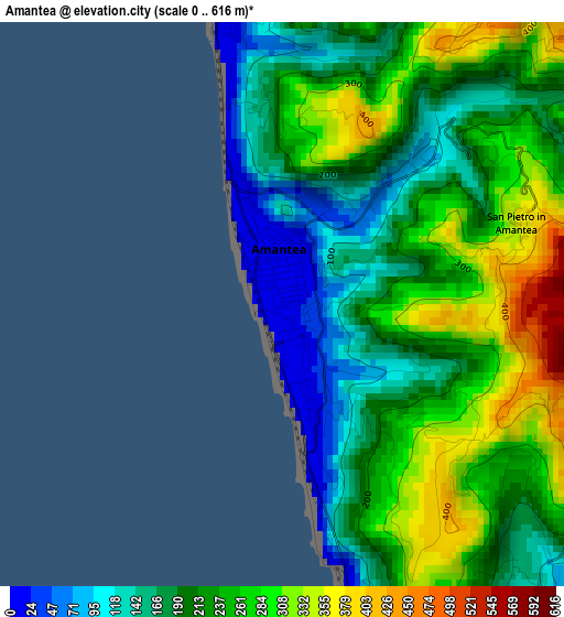
Below is the Elevation map of Amantea, which displays elevation range with different colors. Scale of the first map is from 0 to 616 m (0 to 2021 ft) with average elevation of 224.7 meters (=737 ft) [note 1]
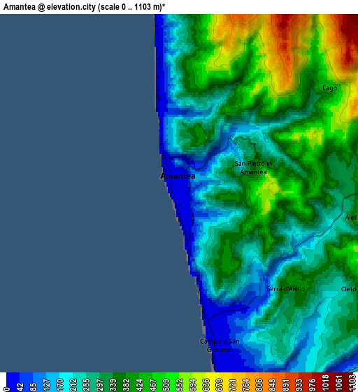
These maps also provides idea of topography and contour of this city, they are displayed at different zoom levels. More info about maps, scale and edge coordinates you can find below images.
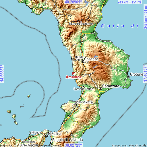
| \ | Map #1 | Map #2 | Topo.Map |
| Scale [m] | 0..616 m | 0..1103 m | × |
| Scale [ft] | 0..2021 ft | 0..3619 ft | × |
| Average | 224.7 m = 737 ft | 338.2 m = 1110 ft | × |
| Width | 7.58 km = 4.7 mi | 15.16 km = 9.4 mi | 242.6 km = 150.7 mi |
| Height | 7.58 km = 4.7 mi | 15.16 km = 9.4 mi | 242.6 km = 150.7 mi |
| ↑Max Latitude | 39.160662° | 39.194728° | 40.20901° |
| Latitude at center | 39.12658° | 39.12658° | 39.12658° |
| ↓Min Latitude | 39.092481° | 39.058366° | 38.02725° |
| ← Min Longitude | 16.031175° | 15.987229° | 14.66887° |
| Longitude center | 16.07512° | 16.07512° | 16.07512° |
| →Max Longitude | 16.119065° | 16.163011° | 17.48137° |
Nearby cities:
Cities around Amantea sort by population:
• Campora San Giovanni elevation 28 m
6.8 km,  164°
164°
• Nocera Scalo 5 m
12.9 km, 162°
• San Mango d'Aquino 452 m
12.5 km,  126°
126°
• Nocera Terinese 367 m
12.9 km,  142°
142°
• Lago 559 m
8 km,  52°
52°
• Aiello Calabro 470 m
7.8 km,  97°
97°
• Fiumefreddo Bruzio 185 m
12.1 km,  358°
358°
• Belmonte Calabro 340 m
4.2 km,  8°
8°
• Serra d'Aiello 366 m
6 km, 132°
• Longobardi 292 m
9.3 km, 359°
• Cleto 266 m
8.2 km,  119°
119°
• San Pietro in Amantea 379 m
3.4 km,  70°
70°
Multilingual:
 En español:
Amantea elevación 13 m.
 En France:
Amantea élévation 13 m.


Sources and notes:
- [note 1] Map square and city borders are not equal. Map elevation data is calculated only from area inside that square.
- [src 1] Elevation data from geonames database provided with same terms of usage.
- [src 2] The elevation map of Amantea is generated using elevation data from NASA's 3 arcsec (90m) resolution SRTM data.
- [src 3] Base (background) map © OpenStreetMap contributors tiles are generated by Geofabrik and OpenTopoMap.
Copyright & License:
This Amantea Elevation Map is licensed under CC BY-SA. You may reuse any part from this page, if you give a proper credit by linking to this URL:
 More info on terms of use page.