Longobardi elevation
Longobardi (Calabria, Provincia di Cosenza), Italy elevation is 292 meters and Longobardi elevation in feet is 958 ft above sea level [src 1]. Longobardi is a seat of a third-order administrative division (feature code) with elevation that is 30 meters (98 ft) smaller than average city elevation in Italy.
Below is the Elevation map of Longobardi, which displays elevation range with different colors. Scale of the first map is from 2 to 1115 m (7 to 3658 ft) with average elevation of 446.2 meters (=1464 ft) [note 1]
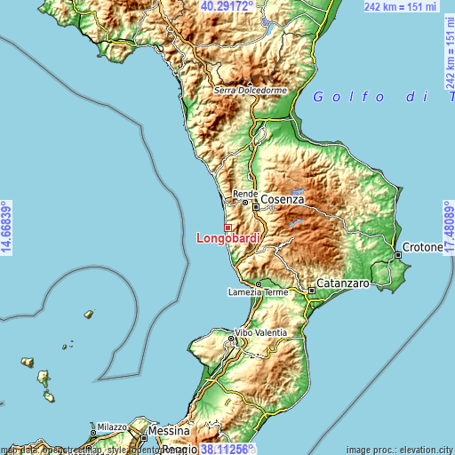
These maps also provides idea of topography and contour of this city, they are displayed at different zoom levels. More info about maps, scale and edge coordinates you can find below images.
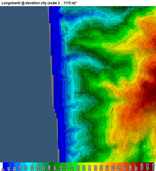
| \ | Map #1 | Topo.Map |
| Scale [m] | 2..1115 m | × |
| Scale [ft] | 7..3658 ft | × |
| Average | 446.2 m = 1464 ft | × |
| Width | 7.57 km = 4.7 mi | 242.3 km = 150.6 mi |
| Height | 7.57 km = 4.7 mi | 242.3 km = 150.6 mi |
| ↑Max Latitude | 39.244632° | 40.29172° |
| Latitude at center | 39.21059° | 39.21059° |
| ↓Min Latitude | 39.176532° | 38.11256° |
| ← Min Longitude | 16.030695° | 14.66839° |
| Longitude center | 16.07464° | 16.07464° |
| →Max Longitude | 16.118585° | 17.48089° |
Nearby cities:
Cities around Longobardi sort by population:
• Amantea elevation 13 m
9.3 km,  179°
179°
• San Lucido 88 m
11.2 km,  350°
350°
• Marano Principato 512 m
12.9 km,  41°
41°
• Cerisano 588 m
11.5 km,  49°
49°
• Mendicino 428 m
11.8 km,  60°
60°
• Lago 559 m
7.7 km,  124°
124°
• Aiello Calabro 470 m
12.9 km,  142°
142°
• Domanico 749 m
11.4 km,  86°
86°
• Fiumefreddo Bruzio 185 m
2.8 km, 352°
• Falconara Albanese 603 m
7.3 km,  9°
9°
• Belmonte Calabro 340 m
5.2 km,  172°
172°
• San Pietro in Amantea 379 m
8.9 km,  158°
158°
Multilingual:
 En español:
Longobardi elevación 292 m.
 En France:
Longobardi élévation 292 m.
 Auf Deutsch:
Longobardi höhe über dem Meeresspiegel ist 292 m.

Sources and notes:
- [note 1] Map square and city borders are not equal. Map elevation data is calculated only from area inside that square.
- [src 1] Elevation data from geonames database provided with same terms of usage.
- [src 2] The elevation map of Longobardi is generated using elevation data from NASA's 3 arcsec (90m) resolution SRTM data.
- [src 3] Base (background) map © OpenStreetMap contributors tiles are generated by Geofabrik and OpenTopoMap.
Copyright & License:
This Longobardi Elevation Map is licensed under CC BY-SA. You may reuse any part from this page, if you give a proper credit by linking to this URL:
 More info on terms of use page.