Bianchi elevation
Bianchi (Calabria, Provincia di Cosenza), Italy elevation is 828 meters and Bianchi elevation in feet is 2717 ft above sea level [src 1]. Bianchi is a seat of a third-order administrative division (feature code) with elevation that is 506 meters (1660 ft) bigger than average city elevation in Italy.
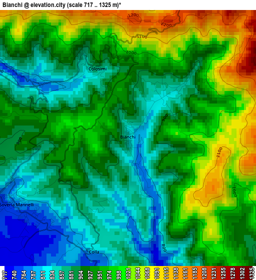
Below is the Elevation map of Bianchi, which displays elevation range with different colors. Scale of the first map is from 717 to 1325 m (2352 to 4347 ft) with average elevation of 934.2 meters (=3065 ft) [note 1]
These maps also provides idea of topography and contour of this city, they are displayed at different zoom levels. More info about maps, scale and edge coordinates you can find below images.
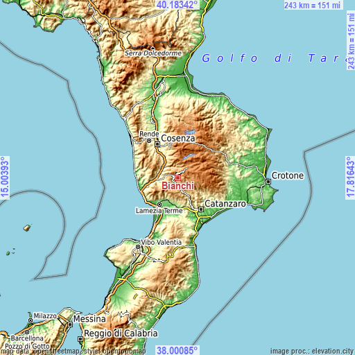
| \ | Map #1 | Topo.Map |
| Scale [m] | 717..1325 m | × |
| Scale [ft] | 2352..4347 ft | × |
| Average | 934.2 m = 3065 ft | × |
| Width | 7.58 km = 4.7 mi | 242.7 km = 150.8 mi |
| Height | 7.58 km = 4.7 mi | 242.7 km = 150.8 mi |
| ↑Max Latitude | 39.134675° | 40.18342° |
| Latitude at center | 39.10058° | 39.10058° |
| ↓Min Latitude | 39.066468° | 38.00085° |
| ← Min Longitude | 16.366235° | 15.00393° |
| Longitude center | 16.41018° | 16.41018° |
| →Max Longitude | 16.454125° | 17.81643° |
Nearby cities:
Cities around Bianchi sort by population:
• Decollatura elevation 778 m
7.5 km,  217°
217°
• Soveria Mannelli 740 m
3.8 km,  228°
228°
• Parenti 849 m
6.7 km,  0°
0°
• Carlopoli 955 m
6.4 km,  143°
143°
• Cicala 858 m
10.9 km, 143°
• Serrastretta 836 m
9.7 km,  176°
176°
• Motta Santa Lucia 527 m
10.2 km,  264°
264°
• Calvisi 651 m
9.5 km,  288°
288°
• Colosimi 869 m
2.3 km,  335°
335°
• Pedivigliano 597 m
9.2 km,  276°
276°
• Panettieri 952 m
5.9 km, 140°
• Carpanzano 590 m
10.5 km,  300°
300°
Multilingual:
 En español:
Bianchi elevación 828 m.
 En France:
Bianchi élévation 828 m.


Sources and notes:
- [note 1] Map square and city borders are not equal. Map elevation data is calculated only from area inside that square.
- [src 1] Elevation data from geonames database provided with same terms of usage.
- [src 2] The elevation map of Bianchi is generated using elevation data from NASA's 3 arcsec (90m) resolution SRTM data.
- [src 3] Base (background) map © OpenStreetMap contributors tiles are generated by Geofabrik and OpenTopoMap.
Copyright & License:
This Bianchi Elevation Map is licensed under CC BY-SA. You may reuse any part from this page, if you give a proper credit by linking to this URL:
 More info on terms of use page.