Panettieri elevation
Panettieri (Calabria, Provincia di Cosenza), Italy elevation is 952 meters and Panettieri elevation in feet is 3123 ft above sea level [src 1]. Panettieri is a seat of a third-order administrative division (feature code) with elevation that is 630 meters (2067 ft) bigger than average city elevation in Italy.
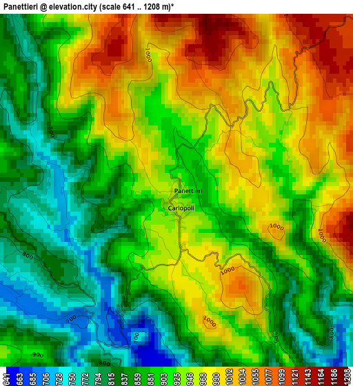
Below is the Elevation map of Panettieri, which displays elevation range with different colors. Scale of the first map is from 641 to 1208 m (2103 to 3963 ft) with average elevation of 913.1 meters (=2996 ft) [note 1]
These maps also provides idea of topography and contour of this city, they are displayed at different zoom levels. More info about maps, scale and edge coordinates you can find below images.
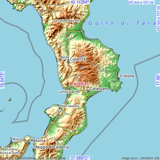
| \ | Map #1 | Topo.Map |
| Scale [m] | 641..1208 m | × |
| Scale [ft] | 2103..3963 ft | × |
| Average | 913.1 m = 2996 ft | × |
| Width | 7.59 km = 4.7 mi | 242.8 km = 150.9 mi |
| Height | 7.59 km = 4.7 mi | 242.8 km = 150.9 mi |
| ↑Max Latitude | 39.094185° | 40.14354° |
| Latitude at center | 39.06007° | 39.06007° |
| ↓Min Latitude | 39.025939° | 37.95972° |
| ← Min Longitude | 16.409805° | 15.0475° |
| Longitude center | 16.45375° | 16.45375° |
| →Max Longitude | 16.497695° | 17.86° |
Nearby cities:
Cities around Panettieri sort by population:
• Gimigliano elevation 530 m
11.8 km,  145°
145°
• Decollatura 778 m
8.4 km,  259°
259°
• Taverna 579 m
11.8 km,  111°
111°
• Soveria Mannelli 740 m
6.9 km,  286°
286°
• Parenti 849 m
11.8 km,  341°
341°
• San Pietro Apostolo 767 m
6.3 km,  168°
168°
• Carlopoli 955 m
0.7 km, 174°
• Cicala 858 m
5.1 km, 146°
• Serrastretta 836 m
6.1 km,  211°
211°
• Sorbo San Basile 613 m
10.9 km, 114°
• Colosimi 869 m
8.1 km,  324°
324°
• Bianchi 828 m
5.9 km, 320°
Multilingual:
 En español:
Panettieri elevación 952 m.
 En France:
Panettieri élévation 952 m.
 Auf Deutsch:
Panettieri höhe über dem Meeresspiegel ist 952 m.

Sources and notes:
- [note 1] Map square and city borders are not equal. Map elevation data is calculated only from area inside that square.
- [src 1] Elevation data from geonames database provided with same terms of usage.
- [src 2] The elevation map of Panettieri is generated using elevation data from NASA's 3 arcsec (90m) resolution SRTM data.
- [src 3] Base (background) map © OpenStreetMap contributors tiles are generated by Geofabrik and OpenTopoMap.
Copyright & License:
This Panettieri Elevation Map is licensed under CC BY-SA. You may reuse any part from this page, if you give a proper credit by linking to this URL:
 More info on terms of use page.