Burcei elevation
Burcei (Sardinia, Provincia del Sud Sardegna), Italy elevation is 647 meters and Burcei elevation in feet is 2123 ft above sea level [src 1]. Burcei is a seat of a third-order administrative division (feature code) with elevation that is 325 meters (1066 ft) bigger than average city elevation in Italy.
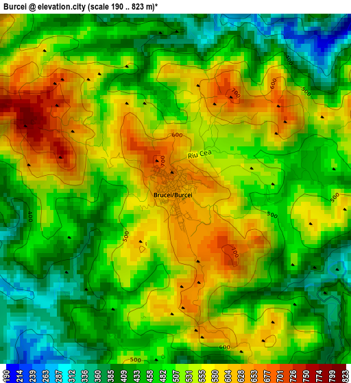
Below is the Elevation map of Burcei, which displays elevation range with different colors. Scale of the first map is from 190 to 823 m (623 to 2700 ft) with average elevation of 504.3 meters (=1655 ft) [note 1]
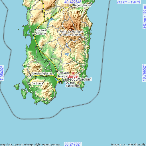
These maps also provides idea of topography and contour of this city, they are displayed at different zoom levels. More info about maps, scale and edge coordinates you can find below images.
| \ | Map #1 | Topo.Map |
| Scale [m] | 190..823 m | × |
| Scale [ft] | 623..2700 ft | × |
| Average | 504.3 m = 1655 ft | × |
| Width | 7.56 km = 4.7 mi | 241.8 km = 150.2 mi |
| Height | 7.56 km = 4.7 mi | 241.8 km = 150.2 mi |
| ↑Max Latitude | 39.377767° | 40.42284° |
| Latitude at center | 39.34379° | 39.34379° |
| ↓Min Latitude | 39.309796° | 38.24782° |
| ← Min Longitude | 9.316325° | 7.95402° |
| Longitude center | 9.36027° | 9.36027° |
| →Max Longitude | 9.404215° | 10.76652° |
Nearby cities:
Cities around Burcei sort by population:
• Quartu Sant'Elena elevation 33 m
15.9 km,  216°
216°
• Sinnai 145 m
14.3 km,  251°
251°
• Quartucciu 15 m
18.7 km,  237°
237°
• Dolianova 225 m
16.2 km,  283°
283°
• Maracalagonis 84 m
13 km, 240°
• Settimo San Pietro 75 m
16.1 km, 248°
• Serdiana 171 m
17.7 km, 281°
• Soleminis 202 m
15.4 km,  271°
271°
• Villasalto 497 m
16.7 km,  8°
8°
• San Nicolo'Gerrei 383 m
17.8 km,  344°
344°
• Olia Speciosa 62 m
15.9 km,  117°
117°
• Castiadas 167 m
16.9 km,  134°
134°
Multilingual:
 En español:
Burcei elevación 647 m.
 En France:
Burcei élévation 647 m.


Sources and notes:
- [note 1] Map square and city borders are not equal. Map elevation data is calculated only from area inside that square.
- [src 1] Elevation data from geonames database provided with same terms of usage.
- [src 2] The elevation map of Burcei is generated using elevation data from NASA's 3 arcsec (90m) resolution SRTM data.
- [src 3] Base (background) map © OpenStreetMap contributors tiles are generated by Geofabrik and OpenTopoMap.
Copyright & License:
This Burcei Elevation Map is licensed under CC BY-SA. You may reuse any part from this page, if you give a proper credit by linking to this URL:
 More info on terms of use page.