Serdiana elevation
Serdiana (Sardinia, Provincia del Sud Sardegna), Italy elevation is 171 meters and Serdiana elevation in feet is 561 ft above sea level [src 1]. Serdiana is a seat of a third-order administrative division (feature code) with elevation that is 151 meters (495 ft) smaller than average city elevation in Italy.
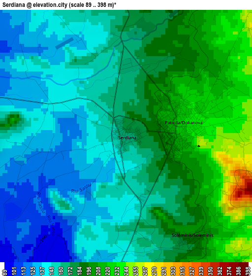
Below is the Elevation map of Serdiana, which displays elevation range with different colors. Scale of the first map is from 89 to 398 m (292 to 1306 ft) with average elevation of 170.7 meters (=560 ft) [note 1]
These maps also provides idea of topography and contour of this city, they are displayed at different zoom levels. More info about maps, scale and edge coordinates you can find below images.
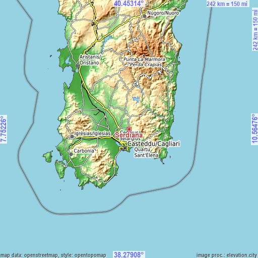
| \ | Map #1 | Topo.Map |
| Scale [m] | 89..398 m | × |
| Scale [ft] | 292..1306 ft | × |
| Average | 170.7 m = 560 ft | × |
| Width | 7.55 km = 4.7 mi | 241.7 km = 150.2 mi |
| Height | 7.55 km = 4.7 mi | 241.7 km = 150.2 mi |
| ↑Max Latitude | 39.408532° | 40.45314° |
| Latitude at center | 39.37457° | 39.37457° |
| ↓Min Latitude | 39.340591° | 38.27908° |
| ← Min Longitude | 9.114565° | 7.75226° |
| Longitude center | 9.15851° | 9.15851° |
| →Max Longitude | 9.202455° | 10.56476° |
Nearby cities:
Cities around Serdiana sort by population:
• Selargius elevation 13 m
13 km,  178°
178°
• Sestu 45 m
10.2 km,  213°
213°
• Sinnai 145 m
8.8 km,  154°
154°
• Dolianova 225 m
1.6 km,  76°
76°
• Maracalagonis 84 m
11.6 km, 148°
• Settimo San Pietro 75 m
9.6 km,  165°
165°
• Monastir 80 m
9.9 km,  275°
275°
• Ussana 98 m
7.5 km,  286°
286°
• Sant'Andrea Frius 295 m
11.7 km,  4°
4°
• Donorì 153 m
6.9 km,  336°
336°
• Soleminis 202 m
3.6 km, 146°
• Barrali 139 m
12.2 km, 336°
Multilingual:
 En español:
Serdiana elevación 171 m.
 En France:
Serdiana élévation 171 m.
 Auf Deutsch:
Serdiana höhe über dem Meeresspiegel ist 171 m.

Sources and notes:
- [note 1] Map square and city borders are not equal. Map elevation data is calculated only from area inside that square.
- [src 1] Elevation data from geonames database provided with same terms of usage.
- [src 2] The elevation map of Serdiana is generated using elevation data from NASA's 3 arcsec (90m) resolution SRTM data.
- [src 3] Base (background) map © OpenStreetMap contributors tiles are generated by Geofabrik and OpenTopoMap.
Copyright & License:
This Serdiana Elevation Map is licensed under CC BY-SA. You may reuse any part from this page, if you give a proper credit by linking to this URL:
 More info on terms of use page.