Camastra elevation
Camastra (Sicily, Agrigento), Italy elevation is 349 meters and Camastra elevation in feet is 1145 ft above sea level [src 1]. Camastra is a seat of a third-order administrative division (feature code) with elevation that is 27 meters (89 ft) bigger than average city elevation in Italy.
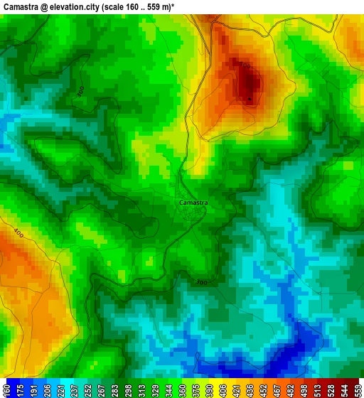
Below is the Elevation map of Camastra, which displays elevation range with different colors. Scale of the first map is from 160 to 559 m (525 to 1834 ft) with average elevation of 318.9 meters (=1046 ft) [note 1]
These maps also provides idea of topography and contour of this city, they are displayed at different zoom levels. More info about maps, scale and edge coordinates you can find below images.
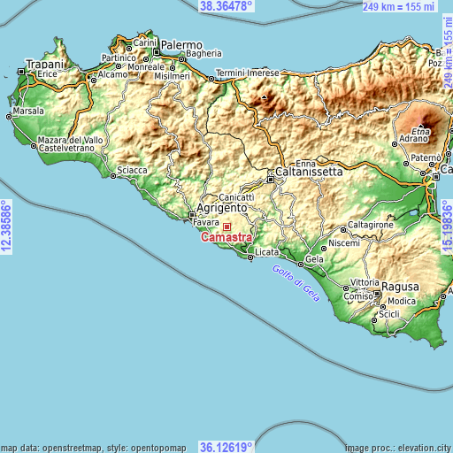
| \ | Map #1 | Topo.Map |
| Scale [m] | 160..559 m | × |
| Scale [ft] | 525..1834 ft | × |
| Average | 318.9 m = 1046 ft | × |
| Width | 7.78 km = 4.8 mi | 248.9 km = 154.7 mi |
| Height | 7.78 km = 4.8 mi | 248.9 km = 154.7 mi |
| ↑Max Latitude | 37.288771° | 38.36478° |
| Latitude at center | 37.2538° | 37.2538° |
| ↓Min Latitude | 37.218813° | 36.12619° |
| ← Min Longitude | 13.748165° | 12.38586° |
| Longitude center | 13.79211° | 13.79211° |
| →Max Longitude | 13.836055° | 15.19836° |
Nearby cities:
Cities around Camastra sort by population:
• Canicattì elevation 458 m
12.6 km,  22°
22°
• Agrigento 261 m
20.1 km,  288°
288°
• Favara 317 m
13.5 km,  301°
301°
• Palma di Montechiaro 176 m
7.4 km,  198°
198°
• San Leone Mosè 10 m
18.4 km,  273°
273°
• Ravanusa 317 m
15.7 km,  84°
84°
• Campobello di Licata 323 m
11.2 km,  87°
87°
• Naro 489 m
4.3 km,  1°
1°
• Racalmuto 501 m
17.7 km,  341°
341°
• Grotte 512 m
18.6 km,  333°
333°
• Delia 438 m
16.7 km,  46°
46°
• Castrofilippo 488 m
11.4 km, 340°
Multilingual:
 En español:
Camastra elevación 349 m.
 En France:
Camastra élévation 349 m.
 Auf Deutsch:
Camastra höhe über dem Meeresspiegel ist 349 m.

Sources and notes:
- [note 1] Map square and city borders are not equal. Map elevation data is calculated only from area inside that square.
- [src 1] Elevation data from geonames database provided with same terms of usage.
- [src 2] The elevation map of Camastra is generated using elevation data from NASA's 3 arcsec (90m) resolution SRTM data.
- [src 3] Base (background) map © OpenStreetMap contributors tiles are generated by Geofabrik and OpenTopoMap.
Copyright & License:
This Camastra Elevation Map is licensed under CC BY-SA. You may reuse any part from this page, if you give a proper credit by linking to this URL:
 More info on terms of use page.