Mirto elevation
Mirto (Calabria, Provincia di Cosenza), Italy elevation is 69 meters and Mirto elevation in feet is 226 ft above sea level [src 1]. Mirto is a populated place (feature code) with elevation that is 253 meters (830 ft) smaller than average city elevation in Italy.
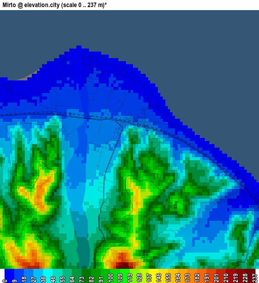
Below is the Elevation map of Mirto, which displays elevation range with different colors. Scale of the first map is from 0 to 237 m (0 to 778 ft) with average elevation of 53.4 meters (=175 ft) [note 1]
These maps also provides idea of topography and contour of this city, they are displayed at different zoom levels. More info about maps, scale and edge coordinates you can find below images.
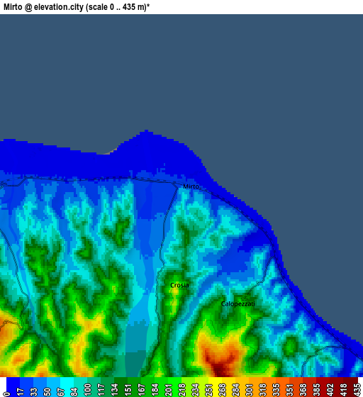
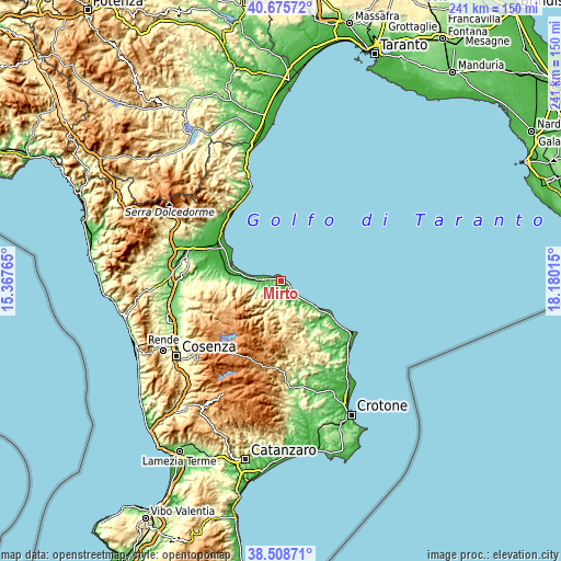
| \ | Map #1 | Map #2 | Topo.Map |
| Scale [m] | 0..237 m | 0..435 m | × |
| Scale [ft] | 0..778 ft | 0..1427 ft | × |
| Average | 53.4 m = 175 ft | 98.2 m = 322 ft | × |
| Width | 7.53 km = 4.7 mi | 15.06 km = 9.4 mi | 240.9 km = 149.7 mi |
| Height | 7.53 km = 4.7 mi | 15.06 km = 9.4 mi | 240.9 km = 149.7 mi |
| ↑Max Latitude | 39.634542° | 39.668377° | 40.67572° |
| Latitude at center | 39.60069° | 39.60069° | 39.60069° |
| ↓Min Latitude | 39.566822° | 39.532937° | 38.50871° |
| ← Min Longitude | 16.729955° | 16.686009° | 15.36765° |
| Longitude center | 16.7739° | 16.7739° | 16.7739° |
| →Max Longitude | 16.817845° | 16.861791° | 18.18015° |
Nearby cities:
Cities around Mirto sort by population:
• Rossano Stazione elevation 55 m
11.9 km,  268°
268°
• Cariati 9 m
19.4 km,  126°
126°
• Rossano 271 m
12.3 km,  257°
257°
• Mandatoriccio 552 m
15.8 km,  160°
160°
• Fabrizio 5 m
19.1 km,  283°
283°
• Amica 36 m
9.2 km, 270°
• Caloveto 368 m
10.5 km,  186°
186°
• Paludi 438 m
11.3 km,  225°
225°
• Cropalati 355 m
10.2 km,  203°
203°
• Caloppezzati 209 m
5 km,  151°
151°
• Crosia 193 m
3.6 km,  183°
183°
• Pietrapaola 385 m
13.1 km, 164°
Multilingual:
 En español:
Mirto elevación 69 m.
 En France:
Mirto élévation 69 m.


Sources and notes:
- [note 1] Map square and city borders are not equal. Map elevation data is calculated only from area inside that square.
- [src 1] Elevation data from geonames database provided with same terms of usage.
- [src 2] The elevation map of Mirto is generated using elevation data from NASA's 3 arcsec (90m) resolution SRTM data.
- [src 3] Base (background) map © OpenStreetMap contributors tiles are generated by Geofabrik and OpenTopoMap.
Copyright & License:
This Mirto Elevation Map is licensed under CC BY-SA. You may reuse any part from this page, if you give a proper credit by linking to this URL:
 More info on terms of use page.