Cariati elevation
Cariati (Calabria, Provincia di Cosenza), Italy elevation is 9 meters and Cariati elevation in feet is 30 ft above sea level [src 1]. Cariati is a seat of a third-order administrative division (feature code) with elevation that is 313 meters (1027 ft) smaller than average city elevation in Italy.
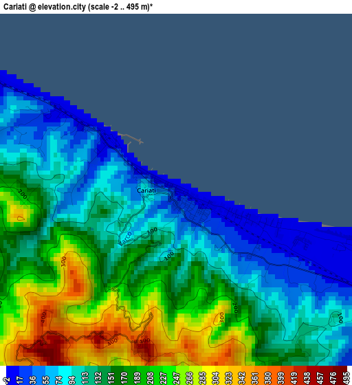
Below is the Elevation map of Cariati, which displays elevation range with different colors. Scale of the first map is from -2 to 495 m (-7 to 1624 ft) with average elevation of 153.7 meters (=504 ft) [note 1]
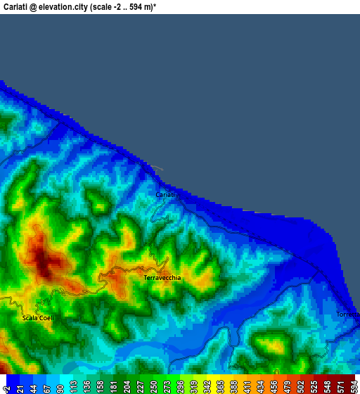
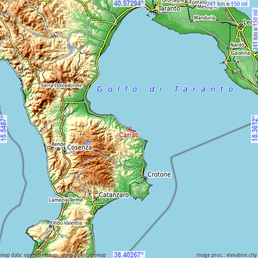
These maps also provides idea of topography and contour of this city, they are displayed at different zoom levels. More info about maps, scale and edge coordinates you can find below images.
| \ | Map #1 | Map #2 | Topo.Map |
| Scale [m] | -2..495 m | -2..594 m | × |
| Scale [ft] | -7..1624 ft | -7..1949 ft | × |
| Average | 153.7 m = 504 ft | 158.2 m = 519 ft | × |
| Width | 7.54 km = 4.7 mi | 15.08 km = 9.4 mi | 241.3 km = 149.9 mi |
| Height | 7.54 km = 4.7 mi | 15.08 km = 9.4 mi | 241.3 km = 149.9 mi |
| ↑Max Latitude | 39.530173° | 39.564059° | 40.57294° |
| Latitude at center | 39.49627° | 39.49627° | 39.49627° |
| ↓Min Latitude | 39.462351° | 39.428415° | 38.40267° |
| ← Min Longitude | 16.911005° | 16.867059° | 15.5487° |
| Longitude center | 16.95495° | 16.95495° | 16.95495° |
| →Max Longitude | 16.998895° | 17.042841° | 18.3612° |
Nearby cities:
Cities around Cariati sort by population:
• Cirò elevation 260 m
15.7 km,  143°
143°
• Torretta 17 m
8.4 km,  124°
124°
• Mandatoriccio 552 m
10.9 km,  252°
252°
• Campana 620 m
14.6 km,  231°
231°
• Caloveto 368 m
16.7 km,  273°
273°
• Terravecchia 447 m
3.5 km,  192°
192°
• Scala Coeli 345 m
7.9 km, 227°
• Crucoli 318 m
8.7 km,  151°
151°
• Caloppezzati 209 m
15 km,  298°
298°
• Crosia 193 m
17.7 km, 296°
• Umbriatico 406 m
16.2 km, 191°
• Pietrapaola 385 m
12 km, 265°
Multilingual:
 En español:
Cariati elevación 9 m.
 En France:
Cariati élévation 9 m.


Sources and notes:
- [note 1] Map square and city borders are not equal. Map elevation data is calculated only from area inside that square.
- [src 1] Elevation data from geonames database provided with same terms of usage.
- [src 2] The elevation map of Cariati is generated using elevation data from NASA's 3 arcsec (90m) resolution SRTM data.
- [src 3] Base (background) map © OpenStreetMap contributors tiles are generated by Geofabrik and OpenTopoMap.
Copyright & License:
This Cariati Elevation Map is licensed under CC BY-SA. You may reuse any part from this page, if you give a proper credit by linking to this URL:
 More info on terms of use page.