Nissoria elevation
Nissoria (Sicily, Enna), Italy elevation is 678 meters and Nissoria elevation in feet is 2224 ft above sea level [src 1]. Nissoria is a seat of a third-order administrative division (feature code) with elevation that is 356 meters (1168 ft) bigger than average city elevation in Italy.
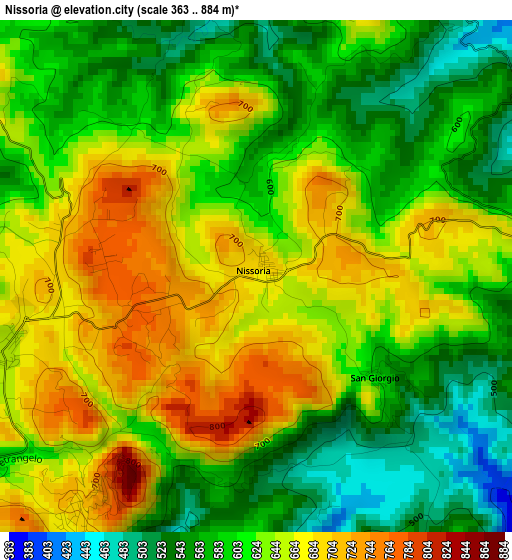
Below is the Elevation map of Nissoria, which displays elevation range with different colors. Scale of the first map is from 363 to 884 m (1191 to 2900 ft) with average elevation of 622.3 meters (=2042 ft) [note 1]
These maps also provides idea of topography and contour of this city, they are displayed at different zoom levels. More info about maps, scale and edge coordinates you can find below images.
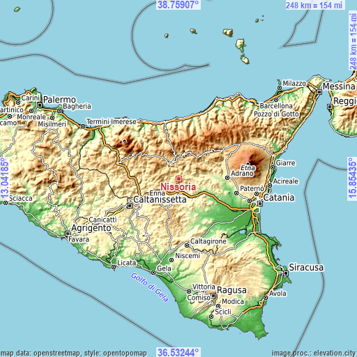
| \ | Map #1 | Topo.Map |
| Scale [m] | 363..884 m | × |
| Scale [ft] | 1191..2900 ft | × |
| Average | 622.3 m = 2042 ft | × |
| Width | 7.74 km = 4.8 mi | 247.6 km = 153.9 mi |
| Height | 7.74 km = 4.8 mi | 247.6 km = 153.9 mi |
| ↑Max Latitude | 37.688884° | 38.75907° |
| Latitude at center | 37.6541° | 37.6541° |
| ↓Min Latitude | 37.6193° | 36.53244° |
| ← Min Longitude | 14.404155° | 13.04185° |
| Longitude center | 14.4481° | 14.4481° |
| →Max Longitude | 14.492045° | 15.85435° |
Nearby cities:
Cities around Nissoria sort by population:
• Enna elevation 935 m
18.2 km,  237°
237°
• Leonforte 630 m
4.6 km,  253°
253°
• Nicosia 731 m
11.5 km,  334°
334°
• Troina 1055 m
19.5 km,  41°
41°
• Agira 625 m
6.3 km,  88°
88°
• Valguarnera Caropepe 593 m
18.4 km,  196°
196°
• Regalbuto 501 m
16.8 km, 90°
• Assoro 706 m
4.4 km,  216°
216°
• Gagliano Castelferrato 662 m
9.8 km,  51°
51°
• Calascibetta 825 m
17.1 km, 245°
• Cerami 951 m
18 km,  16°
16°
• Sperlinga 719 m
15.2 km, 325°
Multilingual:
 En español:
Nissoria elevación 678 m.
 En France:
Nissoria élévation 678 m.
 Auf Deutsch:
Nissoria höhe über dem Meeresspiegel ist 678 m.

Sources and notes:
- [note 1] Map square and city borders are not equal. Map elevation data is calculated only from area inside that square.
- [src 1] Elevation data from geonames database provided with same terms of usage.
- [src 2] The elevation map of Nissoria is generated using elevation data from NASA's 3 arcsec (90m) resolution SRTM data.
- [src 3] Base (background) map © OpenStreetMap contributors tiles are generated by Geofabrik and OpenTopoMap.
Copyright & License:
This Nissoria Elevation Map is licensed under CC BY-SA. You may reuse any part from this page, if you give a proper credit by linking to this URL:
 More info on terms of use page.