Raddusa elevation
Raddusa (Sicily, Catania), Italy elevation is 358 meters and Raddusa elevation in feet is 1175 ft above sea level [src 1]. Raddusa is a seat of a third-order administrative division (feature code) with elevation that is 36 meters (118 ft) bigger than average city elevation in Italy.
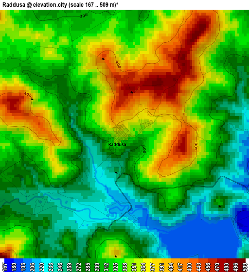
Below is the Elevation map of Raddusa, which displays elevation range with different colors. Scale of the first map is from 167 to 509 m (548 to 1670 ft) with average elevation of 317.4 meters (=1041 ft) [note 1]
These maps also provides idea of topography and contour of this city, they are displayed at different zoom levels. More info about maps, scale and edge coordinates you can find below images.
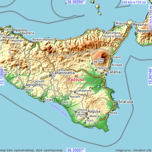
| \ | Map #1 | Topo.Map |
| Scale [m] | 167..509 m | × |
| Scale [ft] | 548..1670 ft | × |
| Average | 317.4 m = 1041 ft | × |
| Width | 7.76 km = 4.8 mi | 248.2 km = 154.2 mi |
| Height | 7.76 km = 4.8 mi | 248.2 km = 154.2 mi |
| ↑Max Latitude | 37.510158° | 38.58295° |
| Latitude at center | 37.47529° | 37.47529° |
| ↓Min Latitude | 37.440406° | 36.35097° |
| ← Min Longitude | 14.491265° | 13.12896° |
| Longitude center | 14.53521° | 14.53521° |
| →Max Longitude | 14.579155° | 15.94146° |
Nearby cities:
Cities around Raddusa sort by population:
• Piazza Armerina elevation 703 m
17.8 km,  235°
235°
• Leonforte 630 m
22.1 km,  326°
326°
• Ramacca 263 m
17.1 km,  125°
125°
• Agira 625 m
20.1 km,  356°
356°
• Valguarnera Caropepe 593 m
13 km,  279°
279°
• Regalbuto 501 m
21.7 km,  25°
25°
• Mirabella Imbaccari 482 m
18.3 km,  205°
205°
• Aidone 825 m
10.4 km,  229°
229°
• Catenanuova 179 m
17.2 km,  52°
52°
• Assoro 706 m
19.3 km, 327°
• Nissoria 678 m
21.3 km,  338°
338°
• Castel di Judica 461 m
10.1 km,  77°
77°
Multilingual:
 En español:
Raddusa elevación 358 m.
 En France:
Raddusa élévation 358 m.


Sources and notes:
- [note 1] Map square and city borders are not equal. Map elevation data is calculated only from area inside that square.
- [src 1] Elevation data from geonames database provided with same terms of usage.
- [src 2] The elevation map of Raddusa is generated using elevation data from NASA's 3 arcsec (90m) resolution SRTM data.
- [src 3] Base (background) map © OpenStreetMap contributors tiles are generated by Geofabrik and OpenTopoMap.
Copyright & License:
This Raddusa Elevation Map is licensed under CC BY-SA. You may reuse any part from this page, if you give a proper credit by linking to this URL:
 More info on terms of use page.