Riesi elevation
Riesi (Sicily, Provincia di Caltanissetta), Italy elevation is 337 meters and Riesi elevation in feet is 1106 ft above sea level [src 1]. Riesi is a seat of a third-order administrative division (feature code) with elevation that is 15 meters (49 ft) bigger than average city elevation in Italy.
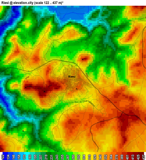
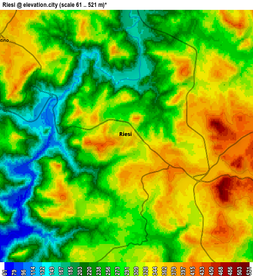
Below is the Elevation map of Riesi, which displays elevation range with different colors. Scale of the first map is from 122 to 437 m (400 to 1434 ft) with average elevation of 294.5 meters (=966 ft) [note 1]
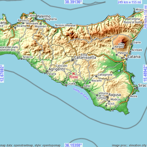
These maps also provides idea of topography and contour of this city, they are displayed at different zoom levels. More info about maps, scale and edge coordinates you can find below images.
| \ | Map #1 | Map #2 | Topo.Map |
| Scale [m] | 122..437 m | 61..521 m | × |
| Scale [ft] | 400..1434 ft | 200..1709 ft | × |
| Average | 294.5 m = 966 ft | 288 m = 945 ft | × |
| Width | 7.78 km = 4.8 mi | 15.55 km = 9.7 mi | 248.8 km = 154.6 mi |
| Height | 7.78 km = 4.8 mi | 15.55 km = 9.7 mi | 248.8 km = 154.6 mi |
| ↑Max Latitude | 37.315748° | 37.35069° | 38.39136° |
| Latitude at center | 37.28079° | 37.28079° | 37.28079° |
| ↓Min Latitude | 37.245816° | 37.210825° | 36.15358° |
| ← Min Longitude | 14.039225° | 13.995279° | 12.67692° |
| Longitude center | 14.08317° | 14.08317° | 14.08317° |
| →Max Longitude | 14.127115° | 14.171061° | 15.48942° |
Nearby cities:
Cities around Riesi sort by population:
• Caltanissetta elevation 579 m
23.4 km,  355°
355°
• Licata 14 m
23.5 km,  212°
212°
• Canicattì 458 m
22.5 km,  292°
292°
• San Cataldo 650 m
24.2 km,  339°
339°
• Barrafranca 456 m
15.2 km,  44°
44°
• Ravanusa 317 m
10.3 km,  261°
261°
• Mazzarino 541 m
11.4 km,  78°
78°
• Campobello di Licata 323 m
14.8 km, 259°
• Sommatino 367 m
9.7 km,  308°
308°
• Pietraperzia 467 m
16 km,  17°
17°
• Butera 328 m
13.3 km,  138°
138°
• Delia 438 m
16.1 km,  302°
302°
Multilingual:
 En español:
Riesi elevación 337 m.
 En France:
Riesi élévation 337 m.


Sources and notes:
- [note 1] Map square and city borders are not equal. Map elevation data is calculated only from area inside that square.
- [src 1] Elevation data from geonames database provided with same terms of usage.
- [src 2] The elevation map of Riesi is generated using elevation data from NASA's 3 arcsec (90m) resolution SRTM data.
- [src 3] Base (background) map © OpenStreetMap contributors tiles are generated by Geofabrik and OpenTopoMap.
Copyright & License:
This Riesi Elevation Map is licensed under CC BY-SA. You may reuse any part from this page, if you give a proper credit by linking to this URL:
 More info on terms of use page.