San Roberto elevation
San Roberto (Calabria, Provincia di Reggio Calabria), Italy elevation is 283 meters and San Roberto elevation in feet is 928 ft above sea level [src 1]. San Roberto is a seat of a third-order administrative division (feature code) with elevation that is 39 meters (128 ft) smaller than average city elevation in Italy.
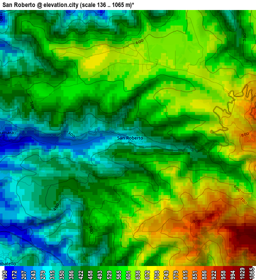
Below is the Elevation map of San Roberto, which displays elevation range with different colors. Scale of the first map is from 136 to 1065 m (446 to 3494 ft) with average elevation of 517 meters (=1696 ft) [note 1]
These maps also provides idea of topography and contour of this city, they are displayed at different zoom levels. More info about maps, scale and edge coordinates you can find below images.
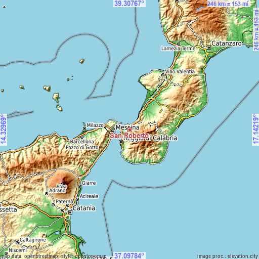
| \ | Map #1 | Topo.Map |
| Scale [m] | 136..1065 m | × |
| Scale [ft] | 446..3494 ft | × |
| Average | 517 m = 1696 ft | × |
| Width | 7.68 km = 4.8 mi | 245.7 km = 152.7 mi |
| Height | 7.68 km = 4.8 mi | 245.7 km = 152.7 mi |
| ↑Max Latitude | 38.245661° | 39.30767° |
| Latitude at center | 38.21114° | 38.21114° |
| ↓Min Latitude | 38.176602° | 37.09784° |
| ← Min Longitude | 15.691995° | 14.32969° |
| Longitude center | 15.73594° | 15.73594° |
| →Max Longitude | 15.779885° | 17.14219° |
Nearby cities:
Cities around San Roberto sort by population:
• Villa San Giovanni elevation 12 m
8.7 km,  276°
276°
• Bagnara Calabra 33 m
10.5 km,  35°
35°
• Campo Calabro 148 m
6.7 km,  274°
274°
• Sant'Eufemia d'Aspromonte 467 m
12 km,  61°
61°
• Scilla 101 m
4.8 km,  341°
341°
• Fiumara 178 m
3.7 km, 272°
• Pavigliana 531 m
11.6 km,  186°
186°
• Santo Stefano in Aspromonte 740 m
6.6 km,  134°
134°
• San Nicola 211 m
3.7 km, 271°
• Sant'Alessio in Aspromonte 580 m
4.7 km,  156°
156°
• Laganadi 500 m
4.2 km,  173°
173°
• Calanna 543 m
3.2 km,  201°
201°
Multilingual:
 En español:
San Roberto elevación 283 m.
 En France:
San Roberto élévation 283 m.
 Auf Deutsch:
San Roberto höhe über dem Meeresspiegel ist 283 m.

Sources and notes:
- [note 1] Map square and city borders are not equal. Map elevation data is calculated only from area inside that square.
- [src 1] Elevation data from geonames database provided with same terms of usage.
- [src 2] The elevation map of San Roberto is generated using elevation data from NASA's 3 arcsec (90m) resolution SRTM data.
- [src 3] Base (background) map © OpenStreetMap contributors tiles are generated by Geofabrik and OpenTopoMap.
Copyright & License:
This San Roberto Elevation Map is licensed under CC BY-SA. You may reuse any part from this page, if you give a proper credit by linking to this URL:
 More info on terms of use page.