Sparta' elevation
Sparta' (Sicily, Messina), Italy elevation is 102 meters and Sparta' elevation in feet is 335 ft above sea level [src 1]. Sparta' is a populated place (feature code) with elevation that is 220 meters (722 ft) smaller than average city elevation in Italy.
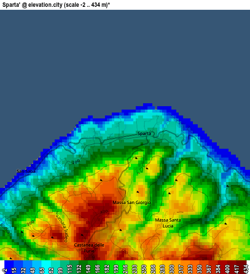
Below is the Elevation map of Sparta', which displays elevation range with different colors. Scale of the first map is from -2 to 434 m (-7 to 1424 ft) with average elevation of 199.9 meters (=656 ft) [note 1]
These maps also provides idea of topography and contour of this city, they are displayed at different zoom levels. More info about maps, scale and edge coordinates you can find below images.
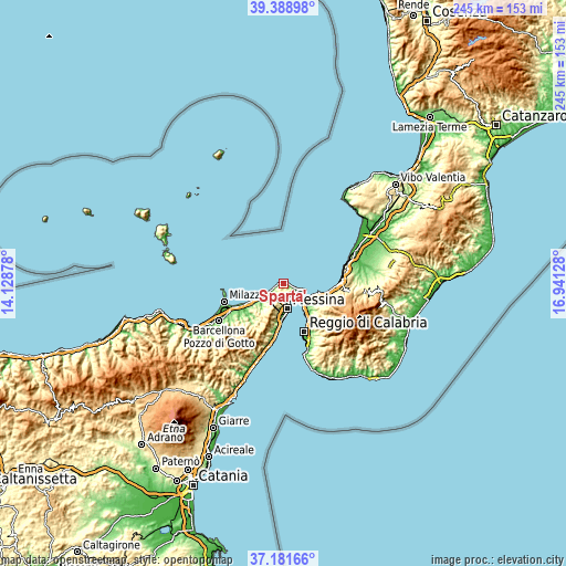
| \ | Map #1 | Topo.Map |
| Scale [m] | -2..434 m | × |
| Scale [ft] | -7..1424 ft | × |
| Average | 199.9 m = 656 ft | × |
| Width | 7.67 km = 4.8 mi | 245.4 km = 152.5 mi |
| Height | 7.67 km = 4.8 mi | 245.4 km = 152.5 mi |
| ↑Max Latitude | 38.328192° | 39.38898° |
| Latitude at center | 38.29371° | 38.29371° |
| ↓Min Latitude | 38.259212° | 37.18166° |
| ← Min Longitude | 15.491085° | 14.12878° |
| Longitude center | 15.53503° | 15.53503° |
| →Max Longitude | 15.578975° | 16.94128° |
Nearby cities:
Cities around Sparta' sort by population:
• Messina elevation 29 m
11.2 km,  172°
172°
• Villa San Giovanni 12 m
12.1 km,  132°
132°
• Villafranca Tirrena 23 m
10.3 km,  234°
234°
• Rometta Marea 12 m
12.9 km,  238°
238°
• Spadafora 14 m
15.5 km, 239°
• Campo Calabro 148 m
13.9 km, 128°
• Faro Superiore 167 m
5.1 km,  124°
124°
• Castanea delle Furie 395 m
3.7 km,  197°
197°
• Saponara Marittima 43 m
11.8 km, 233°
• Saponara 163 m
14.3 km,  217°
217°
• Fiumara 178 m
16.5 km, 123°
• San Nicola 211 m
16.6 km, 123°
Multilingual:
 En español:
Sparta' elevación 102 m.
 En France:
Sparta' élévation 102 m.


Sources and notes:
- [note 1] Map square and city borders are not equal. Map elevation data is calculated only from area inside that square.
- [src 1] Elevation data from geonames database provided with same terms of usage.
- [src 2] The elevation map of Sparta' is generated using elevation data from NASA's 3 arcsec (90m) resolution SRTM data.
- [src 3] Base (background) map © OpenStreetMap contributors tiles are generated by Geofabrik and OpenTopoMap.
Copyright & License:
This Sparta' Elevation Map is licensed under CC BY-SA. You may reuse any part from this page, if you give a proper credit by linking to this URL:
 More info on terms of use page.