Tarsia elevation
Tarsia (Calabria, Provincia di Cosenza), Italy elevation is 210 meters and Tarsia elevation in feet is 689 ft above sea level [src 1]. Tarsia is a seat of a third-order administrative division (feature code) with elevation that is 112 meters (367 ft) smaller than average city elevation in Italy.
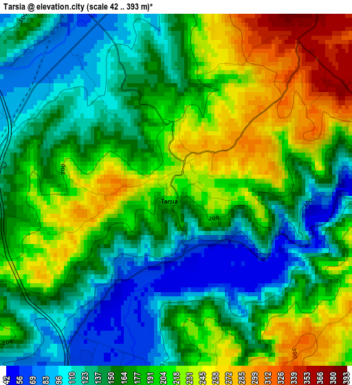
Below is the Elevation map of Tarsia, which displays elevation range with different colors. Scale of the first map is from 42 to 393 m (138 to 1289 ft) with average elevation of 175.8 meters (=577 ft) [note 1]
These maps also provides idea of topography and contour of this city, they are displayed at different zoom levels. More info about maps, scale and edge coordinates you can find below images.
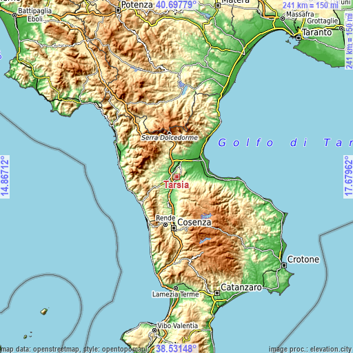
| \ | Map #1 | Topo.Map |
| Scale [m] | 42..393 m | × |
| Scale [ft] | 138..1289 ft | × |
| Average | 175.8 m = 577 ft | × |
| Width | 7.53 km = 4.7 mi | 240.9 km = 149.7 mi |
| Height | 7.53 km = 4.7 mi | 240.9 km = 149.7 mi |
| ↑Max Latitude | 39.656951° | 40.69779° |
| Latitude at center | 39.62311° | 39.62311° |
| ↓Min Latitude | 39.589253° | 38.53148° |
| ← Min Longitude | 16.229425° | 14.86712° |
| Longitude center | 16.27337° | 16.27337° |
| →Max Longitude | 16.317315° | 17.67962° |
Nearby cities:
Cities around Tarsia sort by population:
• Spezzano Albanese elevation 347 m
5.9 km,  31°
31°
• Roggiano Gravina 221 m
9.6 km,  266°
266°
• Bisignano 246 m
12.9 km,  177°
177°
• Terranova da Sibari 287 m
6.7 km,  57°
57°
• San Lorenzo del Vallo 332 m
5.4 km,  23°
23°
• San Demetrio Corone 500 m
9.6 km,  128°
128°
• Firmo 375 m
14.5 km,  319°
319°
• Santa Sofia d'Epiro 558 m
9.8 km,  151°
151°
• Doria 53 m
13.9 km, 30°
• Vaccarizzo Albanese 432 m
14.3 km,  107°
107°
• San Nico 39 m
14.5 km,  69°
69°
• San Cosmo Albanese 362 m
12.9 km, 109°
Multilingual:
 En español:
Tarsia elevación 210 m.
 En France:
Tarsia élévation 210 m.


Sources and notes:
- [note 1] Map square and city borders are not equal. Map elevation data is calculated only from area inside that square.
- [src 1] Elevation data from geonames database provided with same terms of usage.
- [src 2] The elevation map of Tarsia is generated using elevation data from NASA's 3 arcsec (90m) resolution SRTM data.
- [src 3] Base (background) map © OpenStreetMap contributors tiles are generated by Geofabrik and OpenTopoMap.
Copyright & License:
This Tarsia Elevation Map is licensed under CC BY-SA. You may reuse any part from this page, if you give a proper credit by linking to this URL:
 More info on terms of use page.