Torre Melissa elevation
Torre Melissa (Calabria, Provincia di Crotone), Italy elevation is 19 meters and Torre Melissa elevation in feet is 62 ft above sea level [src 1]. Torre Melissa is a populated place (feature code) with elevation that is 303 meters (994 ft) smaller than average city elevation in Italy.
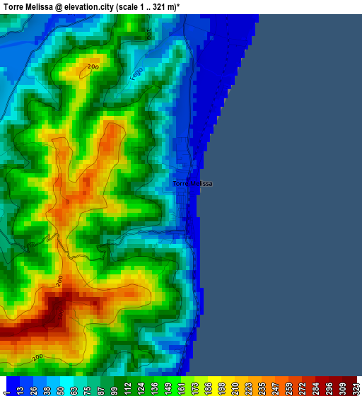
Below is the Elevation map of Torre Melissa, which displays elevation range with different colors. Scale of the first map is from 1 to 321 m (3 to 1053 ft) with average elevation of 116.8 meters (=383 ft) [note 1]
These maps also provides idea of topography and contour of this city, they are displayed at different zoom levels. More info about maps, scale and edge coordinates you can find below images.
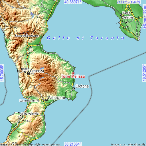
| \ | Map #1 | Topo.Map |
| Scale [m] | 1..321 m | × |
| Scale [ft] | 3..1053 ft | × |
| Average | 116.8 m = 383 ft | × |
| Width | 7.56 km = 4.7 mi | 242 km = 150.4 mi |
| Height | 7.56 km = 4.7 mi | 242 km = 150.4 mi |
| ↑Max Latitude | 39.344123° | 40.38971° |
| Latitude at center | 39.31013° | 39.31013° |
| ↓Min Latitude | 39.27612° | 38.21364° |
| ← Min Longitude | 17.062655° | 15.70035° |
| Longitude center | 17.1066° | 17.1066° |
| →Max Longitude | 17.150545° | 18.51285° |
Nearby cities:
Cities around Torre Melissa sort by population:
• Cirò Marina elevation 8 m
6.7 km,  13°
13°
• Rocca di Neto 48 m
16.5 km,  211°
211°
• Strongoli 295 m
6.7 km,  222°
222°
• Cirò 260 m
8.9 km,  335°
335°
• Casabona 273 m
14.7 km,  242°
242°
• Tronca 8 m
7.1 km,  180°
180°
• Melissa 97 m
6.6 km,  269°
269°
• Pallagorio 551 m
17.1 km, 269°
• San Nicola dell'Alto 538 m
11.8 km,  259°
259°
• Crucoli 318 m
15.8 km,  325°
325°
• Carfizzi 501 m
11.4 km, 268°
• Umbriatico 406 m
16.9 km,  286°
286°
Multilingual:
 En español:
Torre Melissa elevación 19 m.
 En France:
Torre Melissa élévation 19 m.
 Auf Deutsch:
Torre Melissa höhe über dem Meeresspiegel ist 19 m.

Sources and notes:
- [note 1] Map square and city borders are not equal. Map elevation data is calculated only from area inside that square.
- [src 1] Elevation data from geonames database provided with same terms of usage.
- [src 2] The elevation map of Torre Melissa is generated using elevation data from NASA's 3 arcsec (90m) resolution SRTM data.
- [src 3] Base (background) map © OpenStreetMap contributors tiles are generated by Geofabrik and OpenTopoMap.
Copyright & License:
This Torre Melissa Elevation Map is licensed under CC BY-SA. You may reuse any part from this page, if you give a proper credit by linking to this URL:
 More info on terms of use page.