Pallagorio elevation
Pallagorio (Calabria, Provincia di Crotone), Italy elevation is 551 meters and Pallagorio elevation in feet is 1808 ft above sea level [src 1]. Pallagorio is a seat of a third-order administrative division (feature code) with elevation that is 229 meters (751 ft) bigger than average city elevation in Italy.
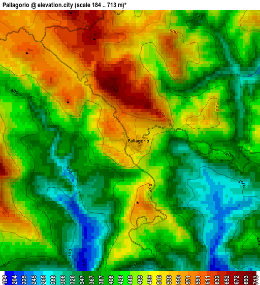
Below is the Elevation map of Pallagorio, which displays elevation range with different colors. Scale of the first map is from 184 to 713 m (604 to 2339 ft) with average elevation of 439.6 meters (=1442 ft) [note 1]
These maps also provides idea of topography and contour of this city, they are displayed at different zoom levels. More info about maps, scale and edge coordinates you can find below images.
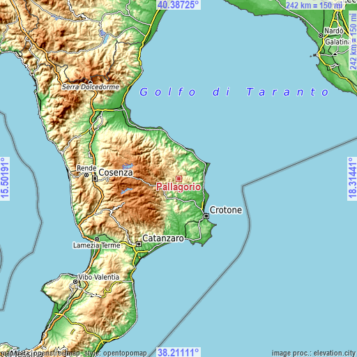
| \ | Map #1 | Topo.Map |
| Scale [m] | 184..713 m | × |
| Scale [ft] | 604..2339 ft | × |
| Average | 439.6 m = 1442 ft | × |
| Width | 7.56 km = 4.7 mi | 242 km = 150.4 mi |
| Height | 7.56 km = 4.7 mi | 242 km = 150.4 mi |
| ↑Max Latitude | 39.341635° | 40.38725° |
| Latitude at center | 39.30764° | 39.30764° |
| ↓Min Latitude | 39.273629° | 38.21111° |
| ← Min Longitude | 16.864215° | 15.50191° |
| Longitude center | 16.90816° | 16.90816° |
| →Max Longitude | 16.952105° | 18.31441° |
Nearby cities:
Cities around Pallagorio sort by population:
• Strongoli elevation 295 m
13.4 km,  110°
110°
• Casabona 273 m
7.6 km,  148°
148°
• Belvedere Spinello 251 m
11.3 km,  186°
186°
• Campana 620 m
13.9 km,  327°
327°
• Verzino 578 m
4.5 km,  277°
277°
• Melissa 97 m
10.5 km,  88°
88°
• Savelli 984 m
11.3 km,  272°
272°
• Cerenzia 625 m
12.5 km,  236°
236°
• Castelsilano 911 m
12.8 km,  250°
250°
• San Nicola dell'Alto 538 m
5.8 km, 108°
• Carfizzi 501 m
5.7 km, 89°
• Umbriatico 406 m
5.2 km,  9°
9°
Multilingual:
 En español:
Pallagorio elevación 551 m.
 En France:
Pallagorio élévation 551 m.
 Auf Deutsch:
Pallagorio höhe über dem Meeresspiegel ist 551 m.

Sources and notes:
- [note 1] Map square and city borders are not equal. Map elevation data is calculated only from area inside that square.
- [src 1] Elevation data from geonames database provided with same terms of usage.
- [src 2] The elevation map of Pallagorio is generated using elevation data from NASA's 3 arcsec (90m) resolution SRTM data.
- [src 3] Base (background) map © OpenStreetMap contributors tiles are generated by Geofabrik and OpenTopoMap.
Copyright & License:
This Pallagorio Elevation Map is licensed under CC BY-SA. You may reuse any part from this page, if you give a proper credit by linking to this URL:
 More info on terms of use page.