Uta elevation
Uta (Sardinia, Provincia di Cagliari), Italy elevation is 7 meters and Uta elevation in feet is 23 ft above sea level [src 1]. Uta is a seat of a third-order administrative division (feature code) with elevation that is 315 meters (1033 ft) smaller than average city elevation in Italy.
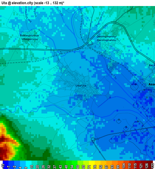
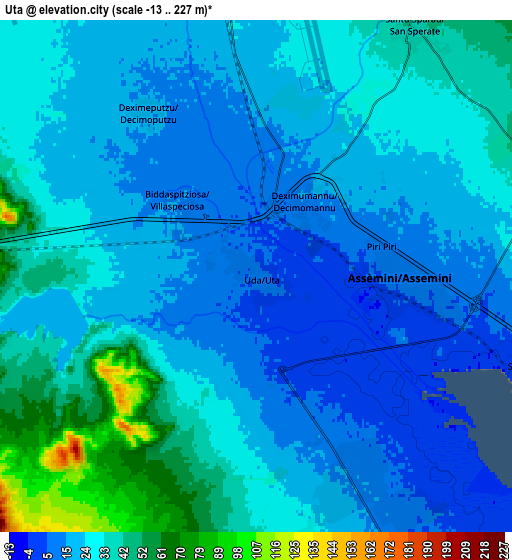
Below is the Elevation map of Uta, which displays elevation range with different colors. Scale of the first map is from -13 to 132 m (-43 to 433 ft) with average elevation of 11.7 meters (=38 ft) [note 1]
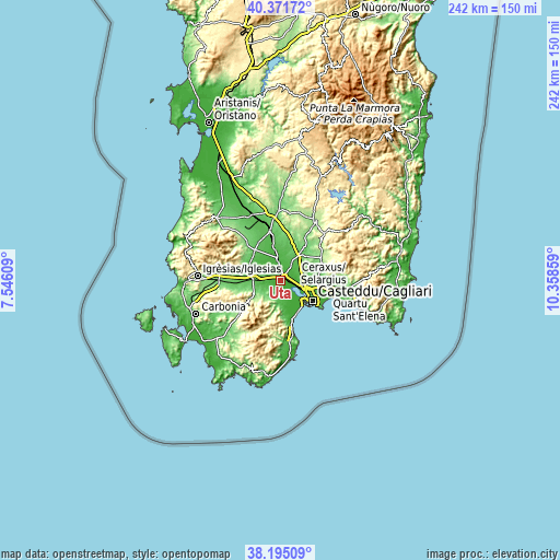
These maps also provides idea of topography and contour of this city, they are displayed at different zoom levels. More info about maps, scale and edge coordinates you can find below images.
| \ | Map #1 | Map #2 | Topo.Map |
| Scale [m] | -13..132 m | -13..227 m | × |
| Scale [ft] | -43..433 ft | -43..745 ft | × |
| Average | 11.7 m = 38 ft | 26.4 m = 87 ft | × |
| Width | 7.56 km = 4.7 mi | 15.13 km = 9.4 mi | 242 km = 150.4 mi |
| Height | 7.56 km = 4.7 mi | 15.13 km = 9.4 mi | 242 km = 150.4 mi |
| ↑Max Latitude | 39.325862° | 39.359848° | 40.37172° |
| Latitude at center | 39.29186° | 39.29186° | 39.29186° |
| ↓Min Latitude | 39.257841° | 39.223806° | 38.19509° |
| ← Min Longitude | 8.908395° | 8.864449° | 7.54609° |
| Longitude center | 8.95234° | 8.95234° | 8.95234° |
| →Max Longitude | 8.996285° | 9.040231° | 10.35859° |
Nearby cities:
Cities around Uta sort by population:
• Assemini elevation 8 m
4 km,  91°
91°
• Sestu 45 m
12.1 km, 86°
• Capoterra 50 m
13.1 km,  172°
172°
• Elmas 8 m
8.8 km,  106°
106°
• Decimomannu 11 m
2.5 km,  35°
35°
• San Sperate 42 m
8.7 km,  33°
33°
• Villasor 27 m
10 km,  355°
355°
• Su Planu 55 m
13.9 km, 107°
• Monastir 80 m
12.9 km, 37°
• Decimoputzu 16 m
5.8 km,  325°
325°
• Siliqua 64 m
12.6 km,  274°
274°
• Villaspeciosa 14 m
3.2 km,  313°
313°


Sources and notes:
- [note 1] Map square and city borders are not equal. Map elevation data is calculated only from area inside that square.
- [src 1] Elevation data from geonames database provided with same terms of usage.
- [src 2] The elevation map of Uta is generated using elevation data from NASA's 3 arcsec (90m) resolution SRTM data.
- [src 3] Base (background) map © OpenStreetMap contributors tiles are generated by Geofabrik and OpenTopoMap.
Copyright & License:
This Uta Elevation Map is licensed under CC BY-SA. You may reuse any part from this page, if you give a proper credit by linking to this URL:
 More info on terms of use page.