Vita elevation
Vita (Sicily, Trapani), Italy elevation is 441 meters and Vita elevation in feet is 1447 ft above sea level [src 1]. Vita is a seat of a third-order administrative division (feature code) with elevation that is 119 meters (390 ft) bigger than average city elevation in Italy.
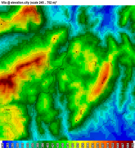
Below is the Elevation map of Vita, which displays elevation range with different colors. Scale of the first map is from 245 to 702 m (804 to 2303 ft) with average elevation of 418 meters (=1371 ft) [note 1]
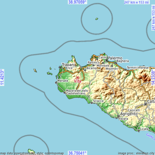
These maps also provides idea of topography and contour of this city, they are displayed at different zoom levels. More info about maps, scale and edge coordinates you can find below images.
| \ | Map #1 | Topo.Map |
| Scale [m] | 245..702 m | × |
| Scale [ft] | 804..2303 ft | × |
| Average | 418 m = 1371 ft | × |
| Width | 7.71 km = 4.8 mi | 246.9 km = 153.4 mi |
| Height | 7.71 km = 4.8 mi | 246.9 km = 153.4 mi |
| ↑Max Latitude | 37.903543° | 38.97059° |
| Latitude at center | 37.86886° | 37.86886° |
| ↓Min Latitude | 37.834161° | 36.75041° |
| ← Min Longitude | 12.783605° | 11.4213° |
| Longitude center | 12.82755° | 12.82755° |
| →Max Longitude | 12.871495° | 14.2338° |
Nearby cities:
Cities around Vita sort by population:
• Alcamo elevation 280 m
17.1 km,  44°
44°
• Castellammare del Golfo 42 m
18.2 km,  15°
15°
• Partanna 409 m
16.7 km,  161°
161°
• Salemi 328 m
5.6 km,  200°
200°
• Santa Ninfa 416 m
11.8 km, 158°
• Calatafimi 349 m
6 km,  32°
32°
• Nuova Gibellina 236 m
7.8 km,  151°
151°
• Buseto Palizzolo 380 m
18.2 km,  325°
325°
• San Ciro-Ulmi-Filci 507 m
5.6 km,  225°
225°
• Sasi 236 m
6.5 km,  55°
55°
• Salaparuta 180 m
20.3 km,  127°
127°
• Fulgatore-Torretta 157 m
14.8 km,  307°
307°
Multilingual:
 En español:
Vita elevación 441 m.
 En France:
Vita élévation 441 m.


Sources and notes:
- [note 1] Map square and city borders are not equal. Map elevation data is calculated only from area inside that square.
- [src 1] Elevation data from geonames database provided with same terms of usage.
- [src 2] The elevation map of Vita is generated using elevation data from NASA's 3 arcsec (90m) resolution SRTM data.
- [src 3] Base (background) map © OpenStreetMap contributors tiles are generated by Geofabrik and OpenTopoMap.
Copyright & License:
This Vita Elevation Map is licensed under CC BY-SA. You may reuse any part from this page, if you give a proper credit by linking to this URL:
 More info on terms of use page.