Buseto Palizzolo elevation
Buseto Palizzolo (Sicily, Trapani), Italy elevation is 380 meters and Buseto Palizzolo elevation in feet is 1247 ft above sea level [src 1]. Buseto Palizzolo is a seat of a third-order administrative division (feature code) with elevation that is 58 meters (190 ft) bigger than average city elevation in Italy.
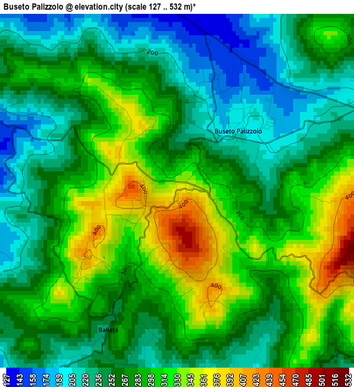
Below is the Elevation map of Buseto Palizzolo, which displays elevation range with different colors. Scale of the first map is from 127 to 532 m (417 to 1745 ft) with average elevation of 274.3 meters (=900 ft) [note 1]
These maps also provides idea of topography and contour of this city, they are displayed at different zoom levels. More info about maps, scale and edge coordinates you can find below images.
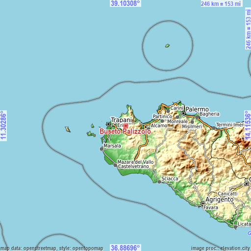
| \ | Map #1 | Topo.Map |
| Scale [m] | 127..532 m | × |
| Scale [ft] | 417..1745 ft | × |
| Average | 274.3 m = 900 ft | × |
| Width | 7.7 km = 4.8 mi | 246.4 km = 153.1 mi |
| Height | 7.7 km = 4.8 mi | 246.4 km = 153.1 mi |
| ↑Max Latitude | 38.03801° | 39.10308° |
| Latitude at center | 38.00339° | 38.00339° |
| ↓Min Latitude | 37.968754° | 36.88696° |
| ← Min Longitude | 12.665165° | 11.30286° |
| Longitude center | 12.70911° | 12.70911° |
| →Max Longitude | 12.753055° | 14.11536° |
Nearby cities:
Cities around Buseto Palizzolo sort by population:
• Trapani elevation 9 m
15.2 km,  275°
275°
• Casa Santa 34 m
14.3 km, 279°
• Castellammare del Golfo 42 m
15.3 km,  80°
80°
• Paceco 41 m
13.5 km,  259°
259°
• Valderice 264 m
9.2 km,  296°
296°
• Calatafimi 349 m
16.8 km,  126°
126°
• Custonaci 203 m
8.7 km,  346°
346°
• Rilievo 55 m
17.7 km,  236°
236°
• Fulgatore-Torretta 157 m
6.1 km,  193°
193°
• Castelluzzo 70 m
11.1 km,  12°
12°
• Tonnara di Bonagia 17 m
12 km, 303°
• Erice 762 m
11.3 km,  289°
289°
Multilingual:
 En español:
Buseto Palizzolo elevación 380 m.
 En France:
Buseto Palizzolo élévation 380 m.
 Auf Deutsch:
Buseto Palizzolo höhe über dem Meeresspiegel ist 380 m.

Sources and notes:
- [note 1] Map square and city borders are not equal. Map elevation data is calculated only from area inside that square.
- [src 1] Elevation data from geonames database provided with same terms of usage.
- [src 2] The elevation map of Buseto Palizzolo is generated using elevation data from NASA's 3 arcsec (90m) resolution SRTM data.
- [src 3] Base (background) map © OpenStreetMap contributors tiles are generated by Geofabrik and OpenTopoMap.
Copyright & License:
This Buseto Palizzolo Elevation Map is licensed under CC BY-SA. You may reuse any part from this page, if you give a proper credit by linking to this URL:
 More info on terms of use page.