Khavāş Kūh elevation
Khavāş Kūh (Yazd), Iran elevation is 1928 meters and Khavāş Kūh elevation in feet is 6325 ft above sea level [src 1]. Khavāş Kūh is a populated place (feature code) with elevation that is 884 meters (2900 ft) bigger than average city elevation in Iran.
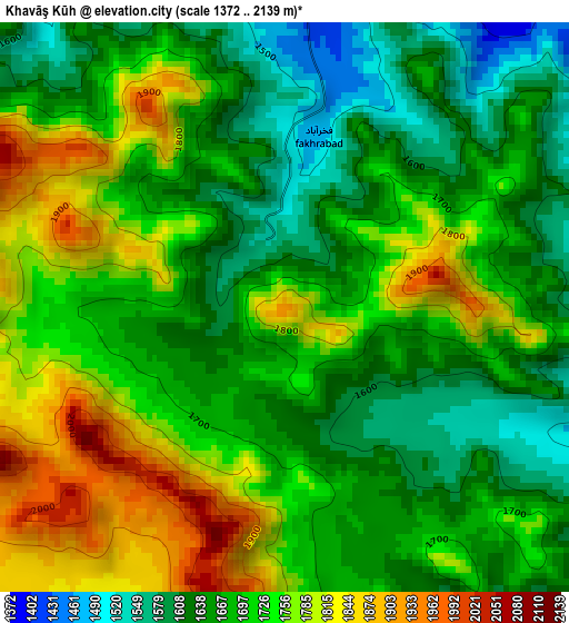
Below is the Elevation map of Khavāş Kūh, which displays elevation range with different colors. Scale of the first map is from 1372 to 2139 m (4501 to 7018 ft) with average elevation of 1703.2 meters (=5588 ft) [note 1]
These maps also provides idea of topography and contour of this city, they are displayed at different zoom levels. More info about maps, scale and edge coordinates you can find below images.
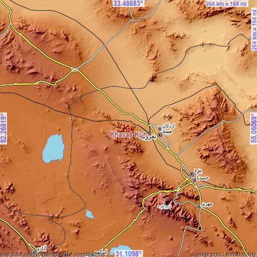
| \ | Map #1 | Topo.Map |
| Scale [m] | 1372..2139 m | × |
| Scale [ft] | 4501..7018 ft | × |
| Average | 1703.2 m = 5588 ft | × |
| Width | 8.26 km = 5.1 mi | 264.3 km = 164.2 mi |
| Height | 8.26 km = 5.1 mi | 264.3 km = 164.2 mi |
| ↑Max Latitude | 32.343245° | 33.48683° |
| Latitude at center | 32.30611° | 32.30611° |
| ↓Min Latitude | 32.26896° | 31.1098° |
| ← Min Longitude | 53.630495° | 52.26819° |
| Longitude center | 53.67444° | 53.67444° |
| →Max Longitude | 53.718385° | 55.08069° |
Nearby cities:
Cities around Khavāş Kūh sort by population:
• Yazd elevation 1216 m
79.6 km,  124°
124°
• Ardakān 1040 m
32.2 km,  89°
89°
• Ābādeh 2006 m
160 km,  217°
217°
• Meybod 1071 m
32.8 km,  100°
100°
• Mahrīz 1475 m
108.2 km,  137°
137°
• Bāfq 991 m
180.8 km, 115°
• Taft 1549 m
79.9 km, 141°
• Ardestān 1215 m
170.3 km,  314°
314°
• Shahreẕā 1823 m
173.3 km,  259°
259°
• Abarkūh 1508 m
136 km,  195°
195°
• Nā’īn 1564 m
82.6 km,  318°
318°
• Taft 1496 m
79.7 km, 139°
Multilingual:
 En español:
Khavāş Kūh elevación 1928 m.
 En France:
Khavāş Kūh élévation 1928 m.
 Auf Deutsch:
Khavāş Kūh höhe über dem Meeresspiegel ist 1928 m.

Sources and notes:
- [note 1] Map square and city borders are not equal. Map elevation data is calculated only from area inside that square.
- [src 1] Elevation data from geonames database provided with same terms of usage.
- [src 2] The elevation map of Khavāş Kūh is generated using elevation data from NASA's 3 arcsec (90m) resolution SRTM data.
- [src 3] Base (background) map © OpenStreetMap contributors tiles are generated by Geofabrik and OpenTopoMap.
Copyright & License:
This Khavāş Kūh Elevation Map is licensed under CC BY-SA. You may reuse any part from this page, if you give a proper credit by linking to this URL:
 More info on terms of use page.