Nā’īn elevation
Nā’īn (Isfahan), Iran elevation is 1564 meters and Nā’īn elevation in feet is 5131 ft above sea level [src 1]. Nā’īn is a seat of a second-order administrative division (feature code) with elevation that is 520 meters (1706 ft) bigger than average city elevation in Iran.
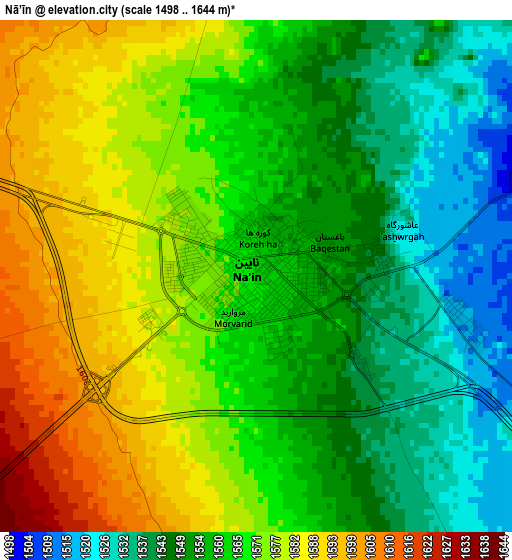
Below is the Elevation map of Nā’īn, which displays elevation range with different colors. Scale of the first map is from 1498 to 1644 m (4915 to 5394 ft) with average elevation of 1563.7 meters (=5130 ft) [note 1]
These maps also provides idea of topography and contour of this city, they are displayed at different zoom levels. More info about maps, scale and edge coordinates you can find below images.
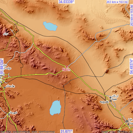
| \ | Map #1 | Topo.Map |
| Scale [m] | 1498..1644 m | × |
| Scale [ft] | 4915..5394 ft | × |
| Average | 1563.7 m = 5130 ft | × |
| Width | 8.21 km = 5.1 mi | 262.7 km = 163.2 mi |
| Height | 8.21 km = 5.1 mi | 262.7 km = 163.2 mi |
| ↑Max Latitude | 32.896966° | 34.03339° |
| Latitude at center | 32.86006° | 32.86006° |
| ↓Min Latitude | 32.823138° | 31.671° |
| ← Min Longitude | 53.043545° | 51.68124° |
| Longitude center | 53.08749° | 53.08749° |
| →Max Longitude | 53.131435° | 54.49374° |
Nearby cities:
Cities around Nā’īn sort by population:
• Isfahan elevation 1578 m
134.1 km,  260°
260°
• Khomeynī Shahr 1595 m
146.3 km, 262°
• Ardakān 1040 m
106.4 km,  125°
125°
• Meybod 1071 m
110.4 km, 127°
• Rehnān 1583 m
140.3 km, 261°
• Dorcheh Pīāz 1599 m
145.8 km, 259°
• Dowlatābād 1569 m
130.2 km,  267°
267°
• Abrīsham 1608 m
145.6 km, 256°
• Ardestān 1215 m
88.1 km,  310°
310°
• Khavāş Kūh 1928 m
82.6 km,  138°
138°
• Shāhīn Shahr 1591 m
143.3 km, 269°
• Naţanz 1637 m
130.7 km,  303°
303°
Multilingual:
 En español:
Nā’īn elevación 1564 m.
 En France:
Nā’īn élévation 1564 m.


Sources and notes:
- [note 1] Map square and city borders are not equal. Map elevation data is calculated only from area inside that square.
- [src 1] Elevation data from geonames database provided with same terms of usage.
- [src 2] The elevation map of Nā’īn is generated using elevation data from NASA's 3 arcsec (90m) resolution SRTM data.
- [src 3] Base (background) map © OpenStreetMap contributors tiles are generated by Geofabrik and OpenTopoMap.
Copyright & License:
This Nā’īn Elevation Map is licensed under CC BY-SA. You may reuse any part from this page, if you give a proper credit by linking to this URL:
 More info on terms of use page.