Khomeynī Shahr elevation
Khomeynī Shahr (Isfahan), Iran elevation is 1595 meters and Khomeynī Shahr elevation in feet is 5233 ft above sea level [src 1]. Khomeynī Shahr is a seat of a second-order administrative division (feature code) with elevation that is 551 meters (1808 ft) bigger than average city elevation in Iran.
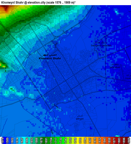
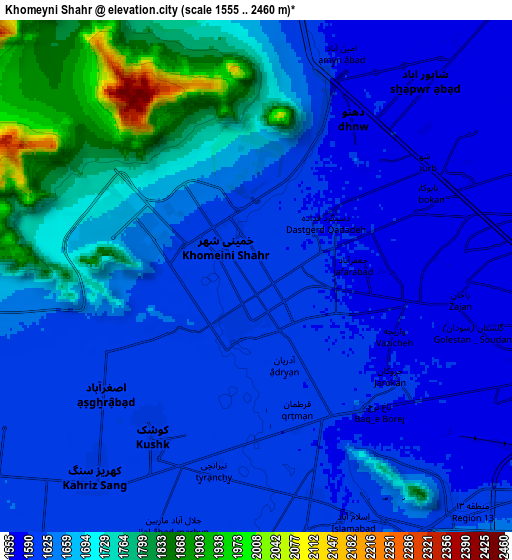
Below is the Elevation map of Khomeynī Shahr, which displays elevation range with different colors. Scale of the first map is from 1576 to 1909 m (5171 to 6263 ft) with average elevation of 1609.6 meters (=5281 ft) [note 1]
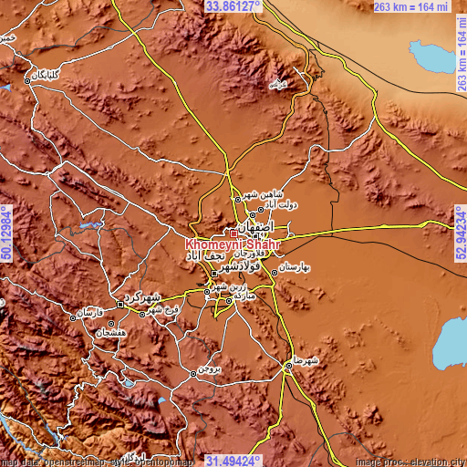
These maps also provides idea of topography and contour of this city, they are displayed at different zoom levels. More info about maps, scale and edge coordinates you can find below images.
| \ | Map #1 | Map #2 | Topo.Map |
| Scale [m] | 1576..1909 m | 1555..2460 m | × |
| Scale [ft] | 5171..6263 ft | 5102..8071 ft | × |
| Average | 1609.6 m = 5281 ft | 1658.6 m = 5442 ft | × |
| Width | 8.22 km = 5.1 mi | 16.45 km = 10.2 mi | 263.2 km = 163.5 mi |
| Height | 8.23 km = 5.1 mi | 16.45 km = 10.2 mi | 263.2 km = 163.5 mi |
| ↑Max Latitude | 32.722579° | 32.759542° | 33.86127° |
| Latitude at center | 32.6856° | 32.6856° | 32.6856° |
| ↓Min Latitude | 32.648606° | 32.611597° | 31.49424° |
| ← Min Longitude | 51.492145° | 51.448199° | 50.12984° |
| Longitude center | 51.53609° | 51.53609° | 51.53609° |
| →Max Longitude | 51.580035° | 51.623981° | 52.94234° |
Nearby cities:
Cities around Khomeynī Shahr sort by population:
• Isfahan elevation 1578 m
13.5 km,  105°
105°
• Najafābād 1649 m
16.8 km,  250°
250°
• Falāvarjān 1609 m
14.7 km,  189°
189°
• Rehnān 1583 m
6.1 km,  92°
92°
• Dorcheh Pīāz 1599 m
8 km,  166°
166°
• Kelīshād va Sūdarjān 1612 m
15 km,  183°
183°
• Dowlatābād 1569 m
19.6 km,  49°
49°
• Qahderījān 1613 m
14.3 km,  212°
212°
• Abrīsham 1608 m
14.8 km, 166°
• Zarrīn Shahr 1705 m
36.1 km,  204°
204°
• Tīrān 1837 m
35.8 km,  273°
273°
• Shāhīn Shahr 1591 m
19.2 km,  4°
4°
Multilingual:
 En español:
Khomeynī Shahr elevación 1595 m.
 En France:
Khomeynī Shahr élévation 1595 m.
 Auf Deutsch:
Khomeynī Shahr höhe über dem Meeresspiegel ist 1595 m.

Sources and notes:
- [note 1] Map square and city borders are not equal. Map elevation data is calculated only from area inside that square.
- [src 1] Elevation data from geonames database provided with same terms of usage.
- [src 2] The elevation map of Khomeynī Shahr is generated using elevation data from NASA's 3 arcsec (90m) resolution SRTM data.
- [src 3] Base (background) map © OpenStreetMap contributors tiles are generated by Geofabrik and OpenTopoMap.
Copyright & License:
This Khomeynī Shahr Elevation Map is licensed under CC BY-SA. You may reuse any part from this page, if you give a proper credit by linking to this URL:
 More info on terms of use page.