Mahrīz elevation
Mahrīz (Yazd), Iran elevation is 1475 meters and Mahrīz elevation in feet is 4839 ft above sea level [src 1]. Mahrīz is a section of populated place (feature code) with elevation that is 431 meters (1414 ft) bigger than average city elevation in Iran.
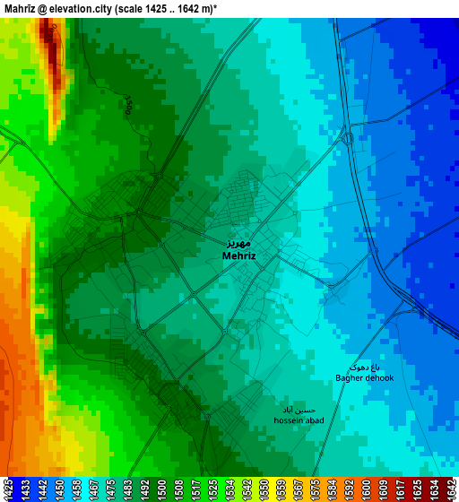
Below is the Elevation map of Mahrīz, which displays elevation range with different colors. Scale of the first map is from 1425 to 1642 m (4675 to 5387 ft) with average elevation of 1485.6 meters (=4874 ft) [note 1]
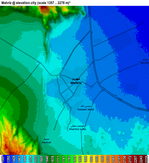
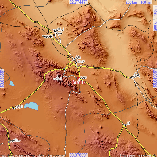
These maps also provides idea of topography and contour of this city, they are displayed at different zoom levels. More info about maps, scale and edge coordinates you can find below images.
| \ | Map #1 | Map #2 | Topo.Map |
| Scale [m] | 1425..1642 m | 1357..2278 m | × |
| Scale [ft] | 4675..5387 ft | 4452..7474 ft | × |
| Average | 1485.6 m = 4874 ft | 1532.5 m = 5028 ft | × |
| Width | 8.32 km = 5.2 mi | 16.65 km = 10.3 mi | 266.4 km = 165.5 mi |
| Height | 8.32 km = 5.2 mi | 16.65 km = 10.3 mi | 266.4 km = 165.5 mi |
| ↑Max Latitude | 31.621708° | 31.659121° | 32.77447° |
| Latitude at center | 31.58428° | 31.58428° | 31.58428° |
| ↓Min Latitude | 31.546837° | 31.509378° | 30.37869° |
| ← Min Longitude | 54.398855° | 54.354909° | 53.03655° |
| Longitude center | 54.4428° | 54.4428° | 54.4428° |
| →Max Longitude | 54.486745° | 54.530691° | 55.84905° |
Nearby cities:
Cities around Mahrīz sort by population:
• Yazd elevation 1216 m
35.5 km,  348°
348°
• Ardakān 1040 m
90.1 km,  333°
333°
• Meybod 1071 m
84.3 km, 331°
• Bāfq 991 m
90.9 km,  88°
88°
• Taft 1549 m
28.8 km,  307°
307°
• Khavāş Kūh 1928 m
108.2 km,  317°
317°
• Şafāshahr 2299 m
160.5 km,  227°
227°
• Bahābād 1404 m
152.9 km,  77°
77°
• Sūrīān 2182 m
146.5 km,  211°
211°
• Abarkūh 1508 m
121.3 km,  245°
245°
• Anār 1409 m
111.7 km,  135°
135°
• Taft 1496 m
28.6 km, 313°
Multilingual:
 En español:
Mahrīz elevación 1475 m.
 En France:
Mahrīz élévation 1475 m.


Sources and notes:
- [note 1] Map square and city borders are not equal. Map elevation data is calculated only from area inside that square.
- [src 1] Elevation data from geonames database provided with same terms of usage.
- [src 2] The elevation map of Mahrīz is generated using elevation data from NASA's 3 arcsec (90m) resolution SRTM data.
- [src 3] Base (background) map © OpenStreetMap contributors tiles are generated by Geofabrik and OpenTopoMap.
Copyright & License:
This Mahrīz Elevation Map is licensed under CC BY-SA. You may reuse any part from this page, if you give a proper credit by linking to this URL:
 More info on terms of use page.