Bāneh elevation
Bāneh (Kordestān), Iran elevation is 1525 meters and Bāneh elevation in feet is 5003 ft above sea level [src 1]. Bāneh is a seat of a second-order administrative division (feature code) with elevation that is 481 meters (1578 ft) bigger than average city elevation in Iran.
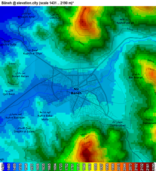
Below is the Elevation map of Bāneh, which displays elevation range with different colors. Scale of the first map is from 1431 to 2190 m (4695 to 7185 ft) with average elevation of 1629.2 meters (=5345 ft) [note 1]
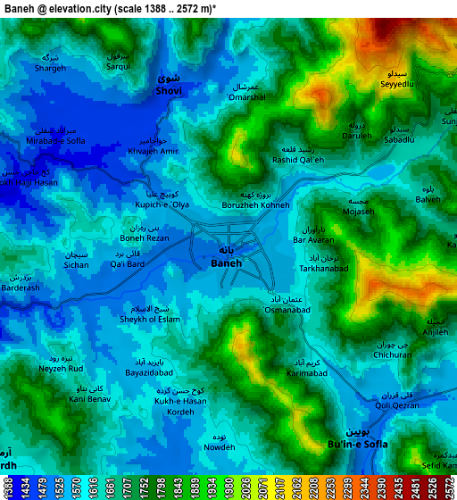
These maps also provides idea of topography and contour of this city, they are displayed at different zoom levels. More info about maps, scale and edge coordinates you can find below images.
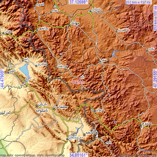
| \ | Map #1 | Map #2 | Topo.Map |
| Scale [m] | 1431..2190 m | 1388..2572 m | × |
| Scale [ft] | 4695..7185 ft | 4554..8438 ft | × |
| Average | 1629.2 m = 5345 ft | 1679.3 m = 5510 ft | × |
| Width | 7.91 km = 4.9 mi | 15.81 km = 9.8 mi | 253 km = 157.2 mi |
| Height | 7.91 km = 4.9 mi | 15.81 km = 9.8 mi | 253 km = 157.2 mi |
| ↑Max Latitude | 36.033046° | 36.068575° | 37.12698° |
| Latitude at center | 35.9975° | 35.9975° | 35.9975° |
| ↓Min Latitude | 35.961938° | 35.926361° | 34.85161° |
| ← Min Longitude | 45.841355° | 45.797409° | 44.47905° |
| Longitude center | 45.8853° | 45.8853° | 45.8853° |
| →Max Longitude | 45.929245° | 45.973191° | 47.29155° |
Nearby cities:
Cities around Bāneh sort by population:
• Būkān elevation 1352 m
65 km,  26°
26°
• Mahābād 1324 m
86.4 km,  350°
350°
• Saqqez 1520 m
44.8 km,  51°
51°
• Mīāndoāb 1294 m
109.6 km,  10°
10°
• Marīvān 1306 m
59.7 km,  153°
153°
• Naqadeh 1325 m
115.4 km,  337°
337°
• Piranshahr 1444 m
102.8 km,  319°
319°
• Shāhīn Dezh 1370 m
97.3 km,  38°
38°
• Pāveh 1525 m
114.3 km,  158°
158°
• Dīvāndarreh 1838 m
102.9 km,  95°
95°
• Sarvābād 1184 m
87.7 km, 150°
• Sardasht 1516 m
40.5 km,  295°
295°
Multilingual:
 En español:
Bāneh elevación 1525 m.
 En France:
Bāneh élévation 1525 m.


Sources and notes:
- [note 1] Map square and city borders are not equal. Map elevation data is calculated only from area inside that square.
- [src 1] Elevation data from geonames database provided with same terms of usage.
- [src 2] The elevation map of Bāneh is generated using elevation data from NASA's 3 arcsec (90m) resolution SRTM data.
- [src 3] Base (background) map © OpenStreetMap contributors tiles are generated by Geofabrik and OpenTopoMap.
Copyright & License:
This Bāneh Elevation Map is licensed under CC BY-SA. You may reuse any part from this page, if you give a proper credit by linking to this URL:
 More info on terms of use page.