Pāveh elevation
Pāveh (Kermānshāh), Iran elevation is 1525 meters and Pāveh elevation in feet is 5003 ft above sea level [src 1]. Pāveh is a seat of a second-order administrative division (feature code) with elevation that is 481 meters (1578 ft) bigger than average city elevation in Iran.
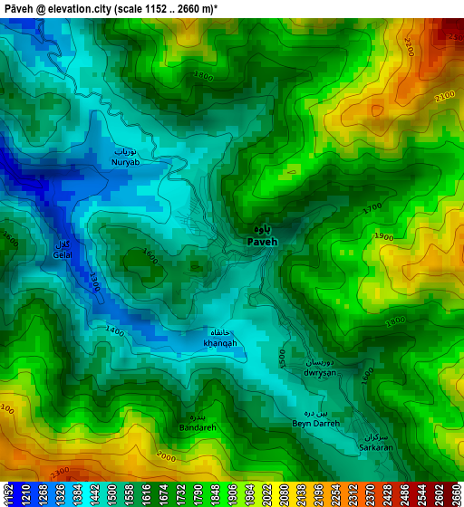
Below is the Elevation map of Pāveh, which displays elevation range with different colors. Scale of the first map is from 1152 to 2660 m (3780 to 8727 ft) with average elevation of 1689 meters (=5541 ft) [note 1]
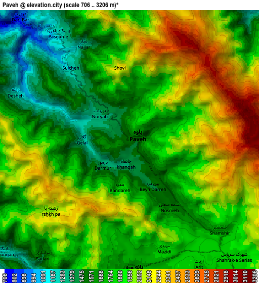
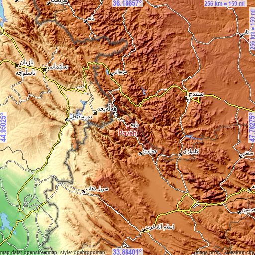
These maps also provides idea of topography and contour of this city, they are displayed at different zoom levels. More info about maps, scale and edge coordinates you can find below images.
| \ | Map #1 | Map #2 | Topo.Map |
| Scale [m] | 1152..2660 m | 706..3206 m | × |
| Scale [ft] | 3780..8727 ft | 2316..10518 ft | × |
| Average | 1689 m = 5541 ft | 1876.3 m = 6156 ft | × |
| Width | 8 km = 5 mi | 16 km = 9.9 mi | 256 km = 159.1 mi |
| Height | 8 km = 5 mi | 16 km = 9.9 mi | 256 km = 159.1 mi |
| ↑Max Latitude | 35.079371° | 35.115326° | 36.18657° |
| Latitude at center | 35.0434° | 35.0434° | 35.0434° |
| ↓Min Latitude | 35.007413° | 34.971411° | 33.88401° |
| ← Min Longitude | 46.312555° | 46.268609° | 44.95025° |
| Longitude center | 46.3565° | 46.3565° | 46.3565° |
| →Max Longitude | 46.400445° | 46.444391° | 47.76275° |
Nearby cities:
Cities around Pāveh sort by population:
• Kahrīz elevation 1302 m
97.3 km,  138°
138°
• Sanandaj 1494 m
65.7 km,  62°
62°
• Marīvān 1306 m
55.1 km,  343°
343°
• Kāmyārān 1470 m
59.5 km,  117°
117°
• Sarpol-e Z̄ahāb 547 m
78.9 km,  214°
214°
• Javānrūd 1418 m
31.2 km,  151°
151°
• Qaşr-e Shīrīn 363 m
92.1 km,  230°
230°
• Kerend-e Gharb 1588 m
85.1 km,  187°
187°
• Ravānsar 1345 m
45.4 km, 143°
• Tāzehābād 1231 m
38.8 km, 209°
• Sarvābād 1184 m
29.9 km,  1°
1°
• Javānrūd 1317 m
29 km, 154°
Multilingual:
 En español:
Pāveh elevación 1525 m.
 En France:
Pāveh élévation 1525 m.


Sources and notes:
- [note 1] Map square and city borders are not equal. Map elevation data is calculated only from area inside that square.
- [src 1] Elevation data from geonames database provided with same terms of usage.
- [src 2] The elevation map of Pāveh is generated using elevation data from NASA's 3 arcsec (90m) resolution SRTM data.
- [src 3] Base (background) map © OpenStreetMap contributors tiles are generated by Geofabrik and OpenTopoMap.
Copyright & License:
This Pāveh Elevation Map is licensed under CC BY-SA. You may reuse any part from this page, if you give a proper credit by linking to this URL:
 More info on terms of use page.