Sarpol-e Z̄ahāb elevation
Sarpol-e Z̄ahāb (Kermānshāh), Iran elevation is 547 meters and Sarpol-e Z̄ahāb elevation in feet is 1795 ft above sea level [src 1]. Sarpol-e Z̄ahāb is a seat of a second-order administrative division (feature code) with elevation that is 497 meters (1631 ft) smaller than average city elevation in Iran.
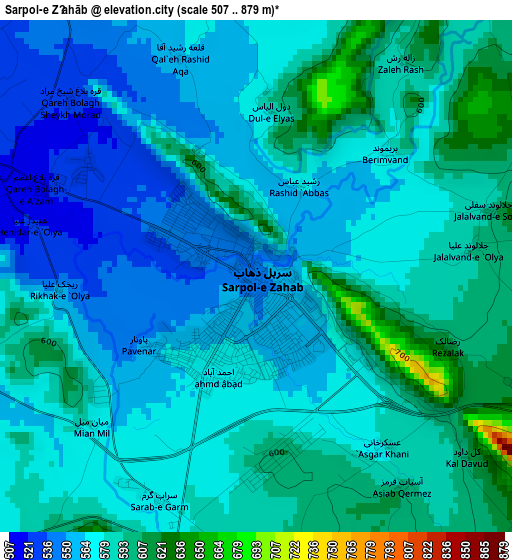
Below is the Elevation map of Sarpol-e Z̄ahāb, which displays elevation range with different colors. Scale of the first map is from 507 to 879 m (1663 to 2884 ft) with average elevation of 575.6 meters (=1888 ft) [note 1]
These maps also provides idea of topography and contour of this city, they are displayed at different zoom levels. More info about maps, scale and edge coordinates you can find below images.
| \ | Map #1 | Map #2 | Topo.Map |
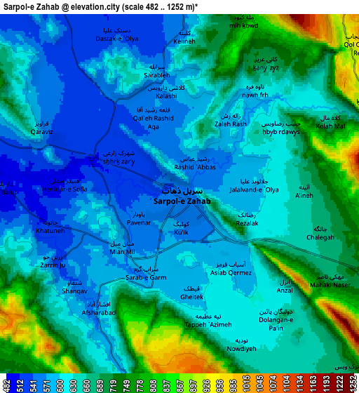
| Scale [m] | 507..879 m | 482..1252 m | × |
| Scale [ft] | 1663..2884 ft | 1581..4108 ft | × |
| Average | 575.6 m = 1888 ft | 651.2 m = 2136 ft | × |
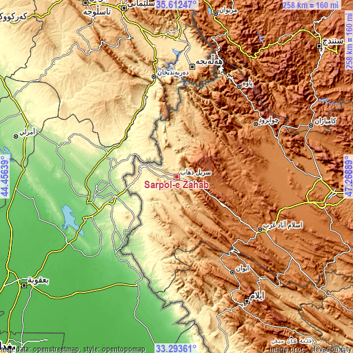
| Width | 8.06 km = 5 mi | 16.12 km = 10 mi | 257.8 km = 160.2 mi |
| Height | 8.06 km = 5 mi | 16.12 km = 10 mi | 257.8 km = 160.2 mi |
| ↑Max Latitude | 34.497316° | 34.533525° | 35.61247° |
| Latitude at center | 34.46109° | 34.46109° | 34.46109° |
| ↓Min Latitude | 34.424849° | 34.388592° | 33.29361° |
| ← Min Longitude | 45.818695° | 45.774749° | 44.45639° |
| Longitude center | 45.86264° | 45.86264° | 45.86264° |
| →Max Longitude | 45.906585° | 45.950531° | 47.26889° |
Nearby cities:
Cities around Sarpol-e Z̄ahāb sort by population:
• Kāmyārān elevation 1470 m
105 km,  69°
69°
• Javānrūd 1418 m
70.5 km,  58°
58°
• Pāveh 1525 m
78.9 km,  34°
34°
• Sarābleh 1027 m
100.7 km,  139°
139°
• Eyvān 1184 m
81.6 km,  149°
149°
• Ravānsar 1345 m
77.7 km, 68°
• Eslāmābād-e Gharb 1332 m
72.5 km,  122°
122°
• Javānrūd 1317 m
69.2 km, 56°
• Tāzehābād 1231 m
40.5 km,  40°
40°
• Kerend-e Gharb 1588 m
40 km, 119°
• Gīlān-e Gharb 802 m
35.9 km,  171°
171°
• Qaşr-e Shīrīn 363 m
26.7 km,  283°
283°
Multilingual:
 En español:
Sarpol-e Z̄ahāb elevación 547 m.
 En France:
Sarpol-e Z̄ahāb élévation 547 m.
 Auf Deutsch:
Sarpol-e Z̄ahāb höhe über dem Meeresspiegel ist 547 m.

Sources and notes:
- [note 1] Map square and city borders are not equal. Map elevation data is calculated only from area inside that square.
- [src 1] Elevation data from geonames database provided with same terms of usage.
- [src 2] The elevation map of Sarpol-e Z̄ahāb is generated using elevation data from NASA's 3 arcsec (90m) resolution SRTM data.
- [src 3] Base (background) map © OpenStreetMap contributors tiles are generated by Geofabrik and OpenTopoMap.
Copyright & License:
This Sarpol-e Z̄ahāb Elevation Map is licensed under CC BY-SA. You may reuse any part from this page, if you give a proper credit by linking to this URL:
 More info on terms of use page.