Sanandaj elevation
Sanandaj (Kordestān), Iran elevation is 1494 meters and Sanandaj elevation in feet is 4902 ft above sea level [src 1]. Sanandaj is a seat of a first-order administrative division (feature code) with elevation that is 450 meters (1476 ft) bigger than average city elevation in Iran.
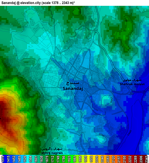
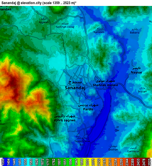
Below is the Elevation map of Sanandaj, which displays elevation range with different colors. Scale of the first map is from 1378 to 2343 m (4521 to 7687 ft) with average elevation of 1593.1 meters (=5227 ft) [note 1]
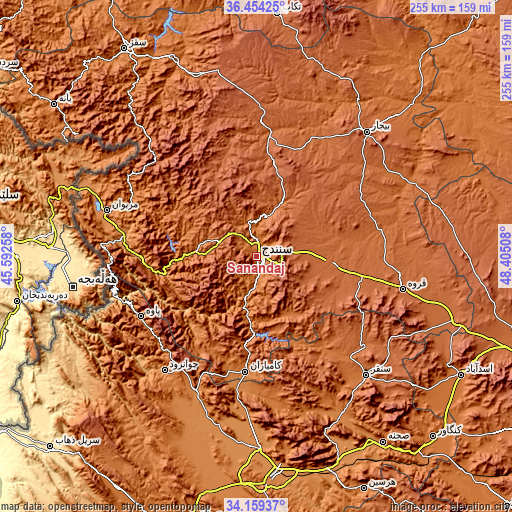
These maps also provides idea of topography and contour of this city, they are displayed at different zoom levels. More info about maps, scale and edge coordinates you can find below images.
| \ | Map #1 | Map #2 | Topo.Map |
| Scale [m] | 1378..2343 m | 1359..2523 m | × |
| Scale [ft] | 4521..7687 ft | 4459..8278 ft | × |
| Average | 1593.1 m = 5227 ft | 1640.7 m = 5383 ft | × |
| Width | 7.97 km = 5 mi | 15.95 km = 9.9 mi | 255.2 km = 158.6 mi |
| Height | 7.97 km = 5 mi | 15.95 km = 9.9 mi | 255.2 km = 158.6 mi |
| ↑Max Latitude | 35.350801° | 35.386636° | 36.45425° |
| Latitude at center | 35.31495° | 35.31495° | 35.31495° |
| ↓Min Latitude | 35.279083° | 35.243201° | 34.15937° |
| ← Min Longitude | 46.954885° | 46.910939° | 45.59258° |
| Longitude center | 46.99883° | 46.99883° | 46.99883° |
| →Max Longitude | 47.042775° | 47.086721° | 48.40508° |
Nearby cities:
Cities around Sanandaj sort by population:
• Marīvān elevation 1306 m
77.3 km,  287°
287°
• Qorveh 1909 m
75.1 km,  102°
102°
• Kāmyārān 1470 m
58 km,  185°
185°
• Bījār 1929 m
82.3 km,  41°
41°
• Sonqor 1697 m
80.6 km,  137°
137°
• Javānrūd 1418 m
72.5 km,  217°
217°
• Pāveh 1525 m
65.7 km,  242°
242°
• Ravānsar 1345 m
73.7 km,  205°
205°
• Javānrūd 1317 m
73 km, 219°
• Dīvāndarreh 1838 m
66.6 km,  1°
1°
• Sarvābād 1184 m
57.3 km,  269°
269°
• Dehgolān 1818 m
38.3 km, 96°
Multilingual:
 En español:
Sanandaj elevación 1494 m.
 En France:
Sanandaj élévation 1494 m.
 Auf Deutsch:
Sanandadsch höhe über dem Meeresspiegel ist 1494 m.

Sources and notes:
- [note 1] Map square and city borders are not equal. Map elevation data is calculated only from area inside that square.
- [src 1] Elevation data from geonames database provided with same terms of usage.
- [src 2] The elevation map of Sanandaj is generated using elevation data from NASA's 3 arcsec (90m) resolution SRTM data.
- [src 3] Base (background) map © OpenStreetMap contributors tiles are generated by Geofabrik and OpenTopoMap.
Copyright & License:
This Sanandaj Elevation Map is licensed under CC BY-SA. You may reuse any part from this page, if you give a proper credit by linking to this URL:
 More info on terms of use page.