Bījār elevation
Bījār (Kordestān), Iran elevation is 1929 meters and Bījār elevation in feet is 6329 ft above sea level [src 1]. Bījār is a populated place (feature code) with elevation that is 885 meters (2904 ft) bigger than average city elevation in Iran.
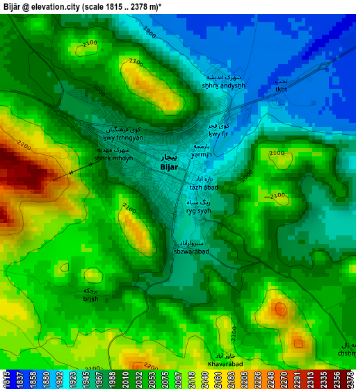
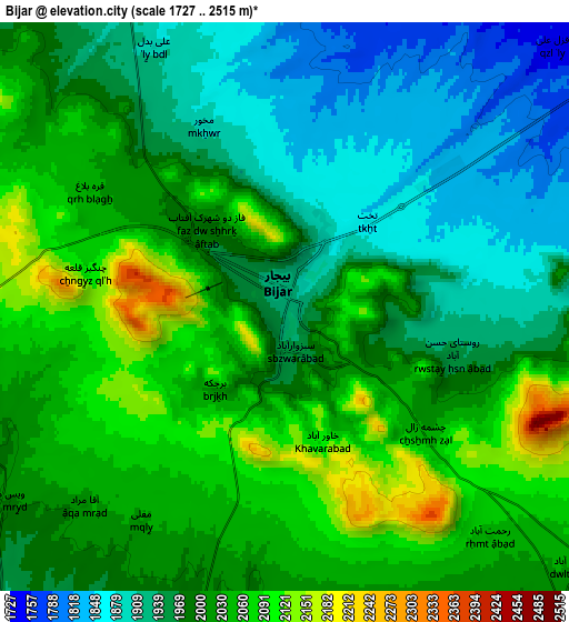
Below is the Elevation map of Bījār, which displays elevation range with different colors. Scale of the first map is from 1815 to 2378 m (5955 to 7802 ft) with average elevation of 2019 meters (=6624 ft) [note 1]
These maps also provides idea of topography and contour of this city, they are displayed at different zoom levels. More info about maps, scale and edge coordinates you can find below images.
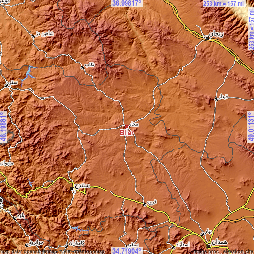
| \ | Map #1 | Map #2 | Topo.Map |
| Scale [m] | 1815..2378 m | 1727..2515 m | × |
| Scale [ft] | 5955..7802 ft | 5666..8251 ft | × |
| Average | 2019 m = 6624 ft | 1996.3 m = 6550 ft | × |
| Width | 7.92 km = 4.9 mi | 15.84 km = 9.8 mi | 253.4 km = 157.5 mi |
| Height | 7.92 km = 4.9 mi | 15.84 km = 9.8 mi | 253.4 km = 157.5 mi |
| ↑Max Latitude | 35.902404° | 35.937993° | 36.99817° |
| Latitude at center | 35.8668° | 35.8668° | 35.8668° |
| ↓Min Latitude | 35.83118° | 35.795543° | 34.71904° |
| ← Min Longitude | 47.561115° | 47.517169° | 46.19881° |
| Longitude center | 47.60506° | 47.60506° | 47.60506° |
| →Max Longitude | 47.649005° | 47.692951° | 49.01131° |
Nearby cities:
Cities around Bījār sort by population:
• Zanjān elevation 1666 m
120.4 km,  41°
41°
• Sanandaj 1494 m
82.3 km,  221°
221°
• Saqqez 1520 m
127 km,  289°
289°
• Qorveh 1909 m
80 km,  166°
166°
• Takāb 1798 m
74 km,  323°
323°
• Sonqor 1697 m
120.6 km,  180°
180°
• Qohūrd-e ‘Olyā 1933 m
63.6 km,  138°
138°
• Kabūdarāhang 1670 m
124.8 km,  125°
125°
• Māhneshān 1300 m
97.8 km,  3°
3°
• Zarrīnābād 1750 m
86.9 km, 44°
• Dehgolān 1818 m
67.6 km,  194°
194°
• Dīvāndarreh 1838 m
52.6 km,  275°
275°
Multilingual:
 En español:
Bījār elevación 1929 m.
 En France:
Bījār élévation 1929 m.


Sources and notes:
- [note 1] Map square and city borders are not equal. Map elevation data is calculated only from area inside that square.
- [src 1] Elevation data from geonames database provided with same terms of usage.
- [src 2] The elevation map of Bījār is generated using elevation data from NASA's 3 arcsec (90m) resolution SRTM data.
- [src 3] Base (background) map © OpenStreetMap contributors tiles are generated by Geofabrik and OpenTopoMap.
Copyright & License:
This Bījār Elevation Map is licensed under CC BY-SA. You may reuse any part from this page, if you give a proper credit by linking to this URL:
 More info on terms of use page.