Zanjān elevation
Zanjān (Zanjan), Iran elevation is 1666 meters and Zanjān elevation in feet is 5466 ft above sea level [src 1]. Zanjān is a seat of a first-order administrative division (feature code) with elevation that is 622 meters (2041 ft) bigger than average city elevation in Iran.
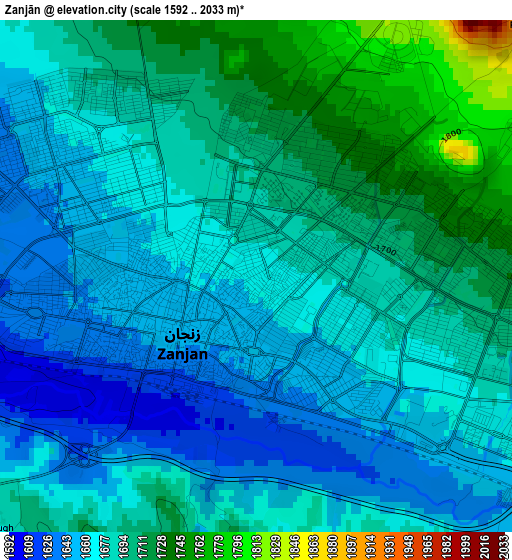
Below is the Elevation map of Zanjān, which displays elevation range with different colors. Scale of the first map is from 1592 to 2033 m (5223 to 6670 ft) with average elevation of 1682 meters (=5518 ft) [note 1]
These maps also provides idea of topography and contour of this city, they are displayed at different zoom levels. More info about maps, scale and edge coordinates you can find below images.
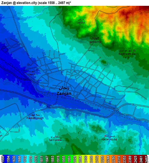
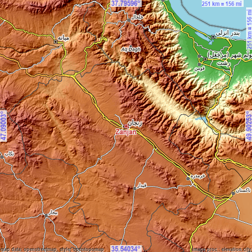
| \ | Map #1 | Map #2 | Topo.Map |
| Scale [m] | 1592..2033 m | 1558..2497 m | × |
| Scale [ft] | 5223..6670 ft | 5112..8192 ft | × |
| Average | 1682 m = 5518 ft | 1760.4 m = 5776 ft | × |
| Width | 7.84 km = 4.9 mi | 15.68 km = 9.7 mi | 250.8 km = 155.8 mi |
| Height | 7.84 km = 4.9 mi | 15.68 km = 9.7 mi | 250.8 km = 155.8 mi |
| ↑Max Latitude | 36.711657° | 36.746878° | 37.79596° |
| Latitude at center | 36.67642° | 36.67642° | 36.67642° |
| ↓Min Latitude | 36.641167° | 36.605898° | 35.54034° |
| ← Min Longitude | 48.452335° | 48.408389° | 47.09003° |
| Longitude center | 48.49628° | 48.49628° | 48.49628° |
| →Max Longitude | 48.540225° | 48.584171° | 49.90253° |
Nearby cities:
Cities around Zanjān sort by population:
• Alvand elevation 1836 m
72 km,  123°
123°
• Abhar 1541 m
87.4 km,  132°
132°
• Khorramdarreh 1582 m
81.4 km, 129°
• Fūman 33 m
94.7 km,  49°
49°
• Pādegān-e Manjīl 362 m
82.3 km,  84°
84°
• Şowme‘eh Sarā 7 m
100.6 km, 46°
• Shaft 45 m
97.3 km,  55°
55°
• Māsāl 61 m
95 km,  36°
36°
• Pā’īn-e Bāzār-e Rūdbār 204 m
84.4 km, 79°
• Māhneshān 1300 m
73.8 km,  275°
275°
• Ābbar 624 m
49.6 km, 55°
• Zarrīnābād 1750 m
33.8 km,  214°
214°
Multilingual:
 En español:
Zanjān elevación 1666 m.
 En France:
Zanjān élévation 1666 m.


Sources and notes:
- [note 1] Map square and city borders are not equal. Map elevation data is calculated only from area inside that square.
- [src 1] Elevation data from geonames database provided with same terms of usage.
- [src 2] The elevation map of Zanjān is generated using elevation data from NASA's 3 arcsec (90m) resolution SRTM data.
- [src 3] Base (background) map © OpenStreetMap contributors tiles are generated by Geofabrik and OpenTopoMap.
Copyright & License:
This Zanjān Elevation Map is licensed under CC BY-SA. You may reuse any part from this page, if you give a proper credit by linking to this URL:
 More info on terms of use page.