Naqadeh elevation
Naqadeh (West Azerbaijan), Iran elevation is 1325 meters and Naqadeh elevation in feet is 4347 ft above sea level [src 1]. Naqadeh is a seat of a second-order administrative division (feature code) with elevation that is 281 meters (922 ft) bigger than average city elevation in Iran.
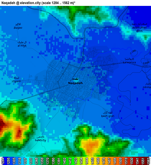
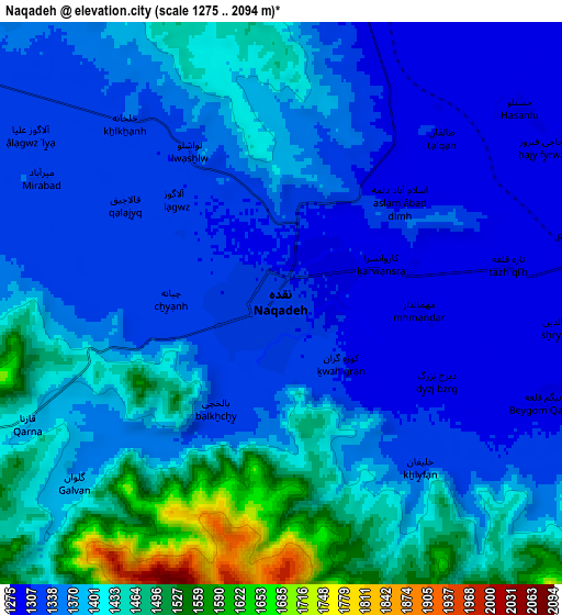
Below is the Elevation map of Naqadeh, which displays elevation range with different colors. Scale of the first map is from 1284 to 1562 m (4213 to 5125 ft) with average elevation of 1325.2 meters (=4348 ft) [note 1]
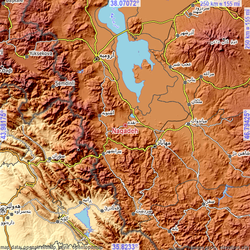
These maps also provides idea of topography and contour of this city, they are displayed at different zoom levels. More info about maps, scale and edge coordinates you can find below images.
| \ | Map #1 | Map #2 | Topo.Map |
| Scale [m] | 1284..1562 m | 1275..2094 m | × |
| Scale [ft] | 4213..5125 ft | 4183..6870 ft | × |
| Average | 1325.2 m = 4348 ft | 1381.8 m = 4533 ft | × |
| Width | 7.81 km = 4.9 mi | 15.62 km = 9.7 mi | 249.9 km = 155.3 mi |
| Height | 7.81 km = 4.9 mi | 15.62 km = 9.7 mi | 249.9 km = 155.3 mi |
| ↑Max Latitude | 36.990409° | 37.025501° | 38.07072° |
| Latitude at center | 36.9553° | 36.9553° | 36.9553° |
| ↓Min Latitude | 36.920175° | 36.885034° | 35.8233° |
| ← Min Longitude | 45.344055° | 45.300109° | 43.98175° |
| Longitude center | 45.388° | 45.388° | 45.388° |
| →Max Longitude | 45.431945° | 45.475891° | 46.79425° |
Nearby cities:
Cities around Naqadeh sort by population:
• Orūmīyeh elevation 1350 m
71.9 km,  337°
337°
• Būkān 1352 m
87.6 km,  123°
123°
• Mahābād 1324 m
36.6 km,  125°
125°
• Mīāndoāb 1294 m
64.1 km,  88°
88°
• Bonāb 1288 m
73.1 km,  54°
54°
• Piranshahr 1444 m
35.8 km,  217°
217°
• Oshnavīyeh 1443 m
27.4 km,  290°
290°
• ‘Ajab Shīr 1297 m
73.4 km,  37°
37°
• Āz̄arshahr 1386 m
103.5 km,  30°
30°
• Marāgheh 1455 m
89.7 km,  57°
57°
• Sardasht 1516 m
89.3 km,  174°
174°
• Malekān 1299 m
66.8 km,  71°
71°
Multilingual:
 En español:
Naqadeh elevación 1325 m.
 En France:
Naghadeh élévation 1325 m.
 Auf Deutsch:
Naqadeh höhe über dem Meeresspiegel ist 1325 m.

Sources and notes:
- [note 1] Map square and city borders are not equal. Map elevation data is calculated only from area inside that square.
- [src 1] Elevation data from geonames database provided with same terms of usage.
- [src 2] The elevation map of Naqadeh is generated using elevation data from NASA's 3 arcsec (90m) resolution SRTM data.
- [src 3] Base (background) map © OpenStreetMap contributors tiles are generated by Geofabrik and OpenTopoMap.
Copyright & License:
This Naqadeh Elevation Map is licensed under CC BY-SA. You may reuse any part from this page, if you give a proper credit by linking to this URL:
 More info on terms of use page.