‘Ajab Shīr elevation
‘Ajab Shīr (East Azerbaijan), Iran elevation is 1297 meters and ‘Ajab Shīr elevation in feet is 4255 ft above sea level [src 1]. ‘Ajab Shīr is a seat of a second-order administrative division (feature code) with elevation that is 253 meters (830 ft) bigger than average city elevation in Iran.
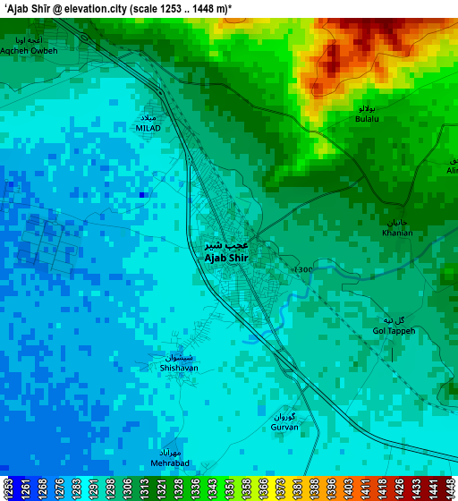
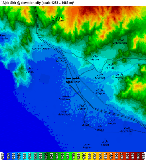
Below is the Elevation map of ‘Ajab Shīr, which displays elevation range with different colors. Scale of the first map is from 1253 to 1448 m (4111 to 4751 ft) with average elevation of 1301.9 meters (=4271 ft) [note 1]
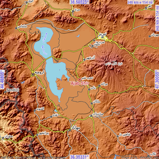
These maps also provides idea of topography and contour of this city, they are displayed at different zoom levels. More info about maps, scale and edge coordinates you can find below images.
| \ | Map #1 | Map #2 | Topo.Map |
| Scale [m] | 1253..1448 m | 1253..1683 m | × |
| Scale [ft] | 4111..4751 ft | 4111..5522 ft | × |
| Average | 1301.9 m = 4271 ft | 1343.7 m = 4408 ft | × |
| Width | 7.76 km = 4.8 mi | 15.51 km = 9.6 mi | 248.2 km = 154.2 mi |
| Height | 7.76 km = 4.8 mi | 15.51 km = 9.6 mi | 248.2 km = 154.2 mi |
| ↑Max Latitude | 37.512466° | 37.547317° | 38.58523° |
| Latitude at center | 37.4776° | 37.4776° | 37.4776° |
| ↓Min Latitude | 37.442717° | 37.407818° | 36.35331° |
| ← Min Longitude | 45.850355° | 45.806409° | 44.48805° |
| Longitude center | 45.8943° | 45.8943° | 45.8943° |
| →Max Longitude | 45.938245° | 45.982191° | 47.30055° |
Nearby cities:
Cities around ‘Ajab Shīr sort by population:
• Tabriz elevation 1396 m
75.5 km,  27°
27°
• Orūmīyeh 1350 m
72.6 km,  276°
276°
• Mahābād 1324 m
80.9 km,  190°
190°
• Mīāndoāb 1294 m
59.9 km,  161°
161°
• Bonāb 1288 m
20.9 km,  136°
136°
• Naqadeh 1325 m
73.4 km,  217°
217°
• Oshnavīyeh 1443 m
85.6 km,  235°
235°
• Shabestar 1433 m
79.9 km,  347°
347°
• Oskū 1512 m
52.6 km,  22°
22°
• Malekān 1299 m
41.6 km,  153°
153°
• Āz̄arshahr 1386 m
32.2 km,  13°
13°
• Marāgheh 1455 m
31.9 km,  107°
107°
Multilingual:
 En español:
‘Ajab Shīr elevación 1297 m.
 En France:
‘Ajab Shīr élévation 1297 m.
 Auf Deutsch:
‘Ajab Shīr höhe über dem Meeresspiegel ist 1297 m.

Sources and notes:
- [note 1] Map square and city borders are not equal. Map elevation data is calculated only from area inside that square.
- [src 1] Elevation data from geonames database provided with same terms of usage.
- [src 2] The elevation map of ‘Ajab Shīr is generated using elevation data from NASA's 3 arcsec (90m) resolution SRTM data.
- [src 3] Base (background) map © OpenStreetMap contributors tiles are generated by Geofabrik and OpenTopoMap.
Copyright & License:
This ‘Ajab Shīr Elevation Map is licensed under CC BY-SA. You may reuse any part from this page, if you give a proper credit by linking to this URL:
 More info on terms of use page.