Behbahān elevation
Behbahān (Khuzestan), Iran elevation is 326 meters and Behbahān elevation in feet is 1070 ft above sea level [src 1]. Behbahān is a seat of a second-order administrative division (feature code) with elevation that is 718 meters (2356 ft) smaller than average city elevation in Iran.
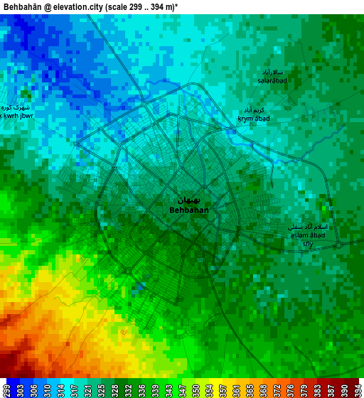
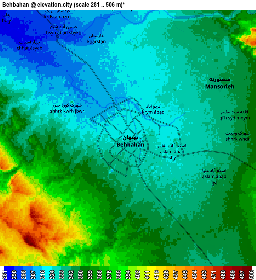
Below is the Elevation map of Behbahān, which displays elevation range with different colors. Scale of the first map is from 299 to 394 m (981 to 1293 ft) with average elevation of 328.9 meters (=1079 ft) [note 1]
These maps also provides idea of topography and contour of this city, they are displayed at different zoom levels. More info about maps, scale and edge coordinates you can find below images.
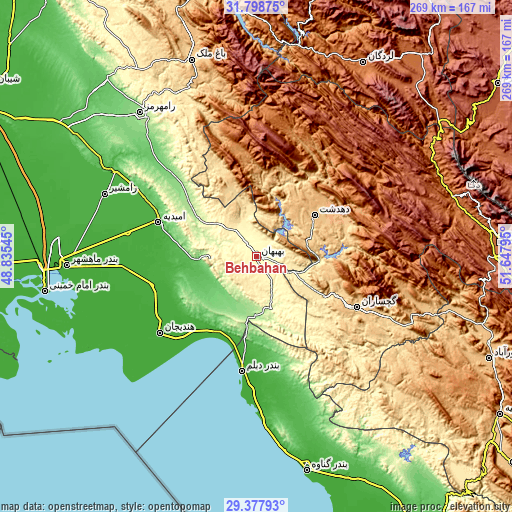
| \ | Map #1 | Map #2 | Topo.Map |
| Scale [m] | 299..394 m | 281..506 m | × |
| Scale [ft] | 981..1293 ft | 922..1660 ft | × |
| Average | 328.9 m = 1079 ft | 344.5 m = 1130 ft | × |
| Width | 8.41 km = 5.2 mi | 16.82 km = 10.5 mi | 269.2 km = 167.3 mi |
| Height | 8.41 km = 5.2 mi | 16.82 km = 10.5 mi | 269.2 km = 167.3 mi |
| ↑Max Latitude | 30.63372° | 30.671525° | 31.79875° |
| Latitude at center | 30.5959° | 30.5959° | 30.5959° |
| ↓Min Latitude | 30.558065° | 30.520216° | 29.37793° |
| ← Min Longitude | 50.197755° | 50.153809° | 48.83545° |
| Longitude center | 50.2417° | 50.2417° | 50.2417° |
| →Max Longitude | 50.285645° | 50.329591° | 51.64795° |
Nearby cities:
Cities around Behbahān sort by population:
• Dogonbadan elevation 723 m
59.5 km,  116°
116°
• Dehdasht 806 m
38 km,  54°
54°
• Omīdīyeh 25 m
54.8 km,  289°
289°
• Rāmhormoz 160 m
97.4 km,  321°
321°
• Aghajari 151 m
40.9 km, 286°
• Rāmshīr 26 m
86.3 km, 292°
• Bāgh-e Malek 711 m
108.6 km,  341°
341°
• Bandar-e Māhshahr 8 m
100.9 km,  267°
267°
• Bāsht 807 m
91.5 km,  106°
106°
• Hendījān 9 m
64.6 km,  231°
231°
• Bandar-e Deylam 5 m
60.8 km,  187°
187°
• Līkak 652 m
36.2 km, 336°
Multilingual:
 En español:
Behbahān elevación 326 m.
 En France:
Behbahān élévation 326 m.
 Auf Deutsch:
Behbahān höhe über dem Meeresspiegel ist 326 m.

Sources and notes:
- [note 1] Map square and city borders are not equal. Map elevation data is calculated only from area inside that square.
- [src 1] Elevation data from geonames database provided with same terms of usage.
- [src 2] The elevation map of Behbahān is generated using elevation data from NASA's 3 arcsec (90m) resolution SRTM data.
- [src 3] Base (background) map © OpenStreetMap contributors tiles are generated by Geofabrik and OpenTopoMap.
Copyright & License:
This Behbahān Elevation Map is licensed under CC BY-SA. You may reuse any part from this page, if you give a proper credit by linking to this URL:
 More info on terms of use page.