Omīdīyeh elevation
Omīdīyeh (Khuzestan), Iran elevation is 25 meters and Omīdīyeh elevation in feet is 82 ft above sea level [src 1]. Omīdīyeh is a seat of a second-order administrative division (feature code) with elevation that is 1019 meters (3343 ft) smaller than average city elevation in Iran.
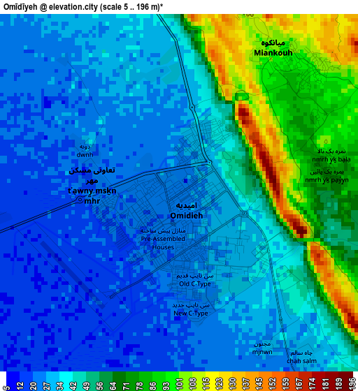
Below is the Elevation map of Omīdīyeh, which displays elevation range with different colors. Scale of the first map is from 5 to 196 m (16 to 643 ft) with average elevation of 44.5 meters (=146 ft) [note 1]
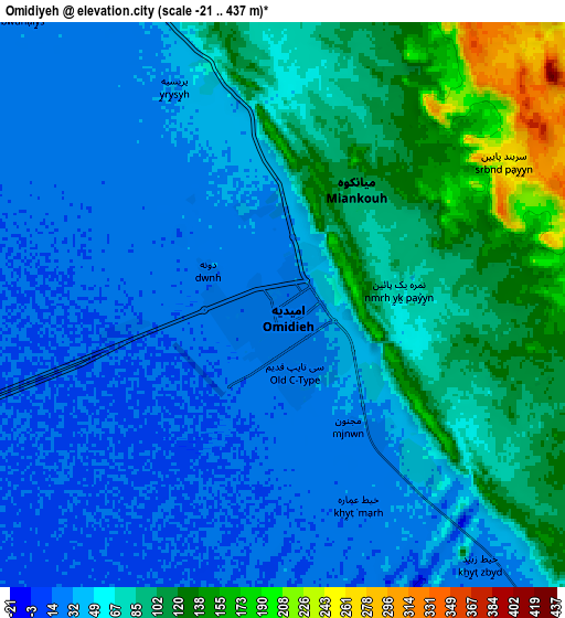
These maps also provides idea of topography and contour of this city, they are displayed at different zoom levels. More info about maps, scale and edge coordinates you can find below images.
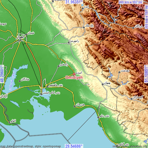
| \ | Map #1 | Map #2 | Topo.Map |
| Scale [m] | 5..196 m | -21..437 m | × |
| Scale [ft] | 16..643 ft | -69..1434 ft | × |
| Average | 44.5 m = 146 ft | 64.4 m = 211 ft | × |
| Width | 8.4 km = 5.2 mi | 16.79 km = 10.4 mi | 268.7 km = 167 mi |
| Height | 8.4 km = 5.2 mi | 16.79 km = 10.4 mi | 268.7 km = 167 mi |
| ↑Max Latitude | 30.800524° | 30.838264° | 31.96351° |
| Latitude at center | 30.76277° | 30.76277° | 30.76277° |
| ↓Min Latitude | 30.725001° | 30.687217° | 29.54686° |
| ← Min Longitude | 49.658315° | 49.614369° | 48.29601° |
| Longitude center | 49.70226° | 49.70226° | 49.70226° |
| →Max Longitude | 49.746205° | 49.790151° | 51.10851° |
Nearby cities:
Cities around Omīdīyeh sort by population:
• Behbahān elevation 326 m
54.8 km,  109°
109°
• Dehdasht 806 m
82.5 km,  87°
87°
• Rāmhormoz 160 m
58.3 km,  350°
350°
• Aghajari 151 m
14.2 km,  119°
119°
• Rāmshīr 26 m
31.6 km,  297°
297°
• Bandar-e Deylam 5 m
90.1 km,  150°
150°
• Bāgh-e Malek 711 m
86.4 km,  11°
11°
• Haftkel 298 m
77.8 km, 347°
• Bandar-e Emam Khomeyni 3 m
67.8 km,  237°
237°
• Hendījān 9 m
58.5 km,  179°
179°
• Bandar-e Māhshahr 8 m
54.2 km, 244°
• Līkak 652 m
40.1 km,  68°
68°
Multilingual:
 En español:
Omīdīyeh elevación 25 m.
 En France:
Omīdīyeh élévation 25 m.


Sources and notes:
- [note 1] Map square and city borders are not equal. Map elevation data is calculated only from area inside that square.
- [src 1] Elevation data from geonames database provided with same terms of usage.
- [src 2] The elevation map of Omīdīyeh is generated using elevation data from NASA's 3 arcsec (90m) resolution SRTM data.
- [src 3] Base (background) map © OpenStreetMap contributors tiles are generated by Geofabrik and OpenTopoMap.
Copyright & License:
This Omīdīyeh Elevation Map is licensed under CC BY-SA. You may reuse any part from this page, if you give a proper credit by linking to this URL:
 More info on terms of use page.