Bīrjand elevation
Bīrjand (Khorāsān-e Jonūbī), Iran elevation is 1459 meters and Bīrjand elevation in feet is 4787 ft above sea level [src 1]. Bīrjand is a seat of a first-order administrative division (feature code) with elevation that is 415 meters (1362 ft) bigger than average city elevation in Iran.
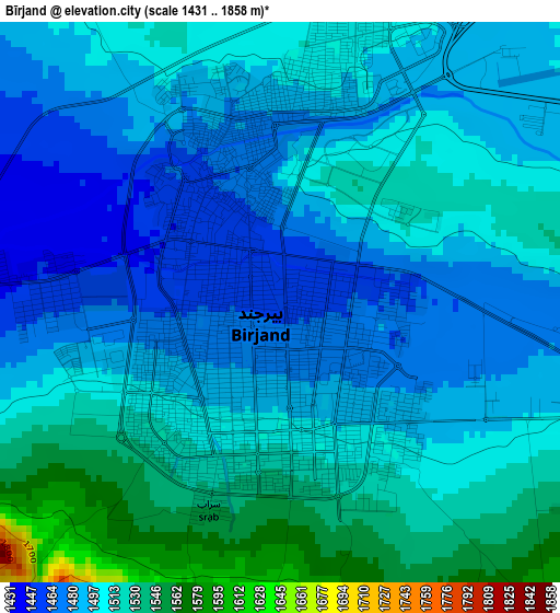
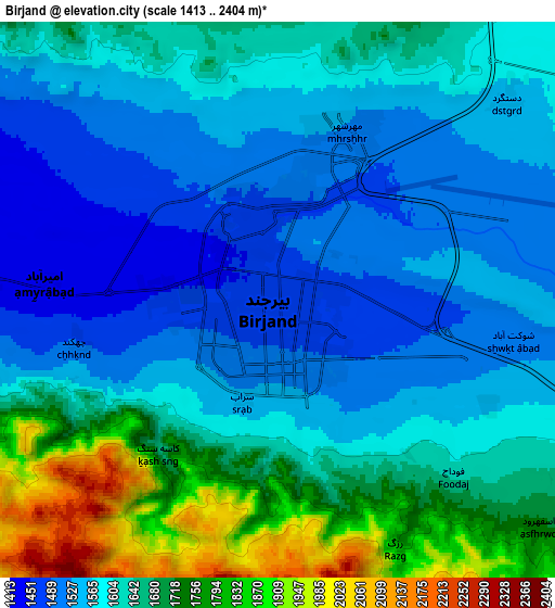
Below is the Elevation map of Bīrjand, which displays elevation range with different colors. Scale of the first map is from 1431 to 1858 m (4695 to 6096 ft) with average elevation of 1500.8 meters (=4924 ft) [note 1]
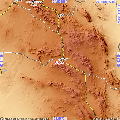
These maps also provides idea of topography and contour of this city, they are displayed at different zoom levels. More info about maps, scale and edge coordinates you can find below images.
| \ | Map #1 | Map #2 | Topo.Map |
| Scale [m] | 1431..1858 m | 1413..2404 m | × |
| Scale [ft] | 4695..6096 ft | 4636..7887 ft | × |
| Average | 1500.8 m = 4924 ft | 1620.5 m = 5317 ft | × |
| Width | 8.21 km = 5.1 mi | 16.42 km = 10.2 mi | 262.7 km = 163.2 mi |
| Height | 8.21 km = 5.1 mi | 16.42 km = 10.2 mi | 262.7 km = 163.2 mi |
| ↑Max Latitude | 32.903184° | 32.940072° | 34.03953° |
| Latitude at center | 32.86628° | 32.86628° | 32.86628° |
| ↓Min Latitude | 32.829361° | 32.792426° | 31.6773° |
| ← Min Longitude | 59.177195° | 59.133249° | 57.81489° |
| Longitude center | 59.22114° | 59.22114° | 59.22114° |
| →Max Longitude | 59.265085° | 59.309031° | 60.62739° |
Nearby cities:
Cities around Bīrjand sort by population:
• Tabas elevation 669 m
228.5 km,  290°
290°
• Gonābād 1095 m
172.6 km,  343°
343°
• Qā’en 1447 m
95.7 km,  357°
357°
• Khvāf 975 m
208.3 km,  24°
24°
• Bajestān 1259 m
207 km,  332°
332°
• Boshrūyeh 879 m
200.3 km,  303°
303°
• Nehbandān 1187 m
166 km,  152°
152°
• Ferdows 1279 m
160.9 km,  322°
322°
• Sarāyān 1449 m
128.2 km, 329°
• Ḩājjīābād 1038 m
109.1 km,  41°
41°
• Sarbīsheh 1824 m
62.9 km,  120°
120°
• Asadīyeh 2170 m
47.3 km,  79°
79°
Multilingual:
 En español:
Bīrjand elevación 1459 m.
 En France:
Birjand élévation 1459 m.
 Auf Deutsch:
Birdschand höhe über dem Meeresspiegel ist 1459 m.

Sources and notes:
- [note 1] Map square and city borders are not equal. Map elevation data is calculated only from area inside that square.
- [src 1] Elevation data from geonames database provided with same terms of usage.
- [src 2] The elevation map of Bīrjand is generated using elevation data from NASA's 3 arcsec (90m) resolution SRTM data.
- [src 3] Base (background) map © OpenStreetMap contributors tiles are generated by Geofabrik and OpenTopoMap.
Copyright & License:
This Bīrjand Elevation Map is licensed under CC BY-SA. You may reuse any part from this page, if you give a proper credit by linking to this URL:
 More info on terms of use page.