Qā’en elevation
Qā’en (Khorāsān-e Jonūbī), Iran elevation is 1447 meters and Qā’en elevation in feet is 4747 ft above sea level [src 1]. Qā’en is a seat of a second-order administrative division (feature code) with elevation that is 403 meters (1322 ft) bigger than average city elevation in Iran.
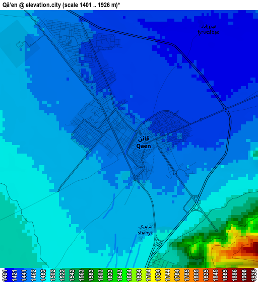
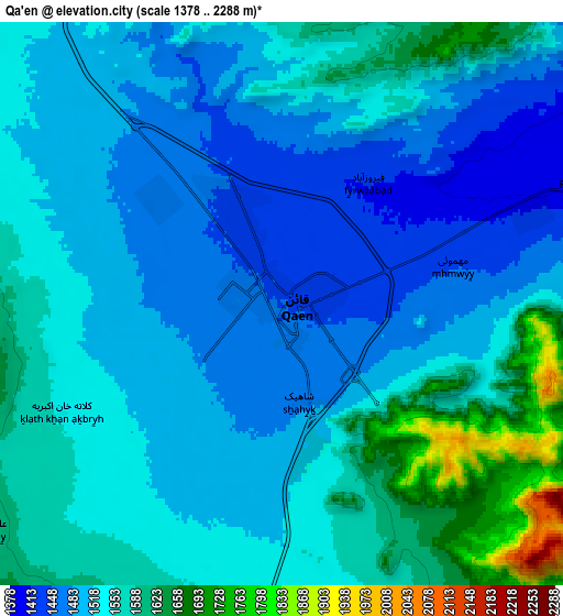
Below is the Elevation map of Qā’en, which displays elevation range with different colors. Scale of the first map is from 1401 to 1926 m (4596 to 6319 ft) with average elevation of 1468.7 meters (=4819 ft) [note 1]
These maps also provides idea of topography and contour of this city, they are displayed at different zoom levels. More info about maps, scale and edge coordinates you can find below images.
| \ | Map #1 | Map #2 | Topo.Map |
| Scale [m] | 1401..1926 m | 1378..2288 m | × |
| Scale [ft] | 4596..6319 ft | 4521..7507 ft | × |
| Average | 1468.7 m = 4819 ft | 1533.7 m = 5032 ft | × |
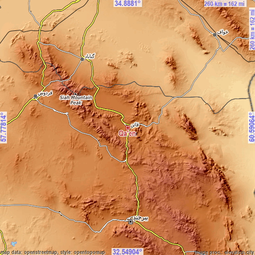
| Width | 8.13 km = 5.1 mi | 16.26 km = 10.1 mi | 260.1 km = 161.6 mi |
| Height | 8.13 km = 5.1 mi | 16.26 km = 10.1 mi | 260.1 km = 161.6 mi |
| ↑Max Latitude | 33.763081° | 33.799607° | 34.8881° |
| Latitude at center | 33.72654° | 33.72654° | 33.72654° |
| ↓Min Latitude | 33.689983° | 33.653411° | 32.54904° |
| ← Min Longitude | 59.140445° | 59.096499° | 57.77814° |
| Longitude center | 59.18439° | 59.18439° | 59.18439° |
| →Max Longitude | 59.228335° | 59.272281° | 60.59064° |
Nearby cities:
Cities around Qā’en sort by population:
• Bīrjand elevation 1459 m
95.7 km,  177°
177°
• Gonābād 1095 m
83.5 km,  326°
326°
• Boshrūyeh 879 m
163 km,  275°
275°
• Feyẕābād 931 m
148.3 km,  345°
345°
• Roshtkhvār 1149 m
144.6 km,  16°
16°
• Sarbīsheh 1824 m
140.1 km,  155°
155°
• Khvāf 975 m
129.1 km,  42°
42°
• Bajestān 1259 m
127.2 km,  313°
313°
• Asadīyeh 2170 m
100.3 km,  150°
150°
• Ferdows 1279 m
98.9 km,  289°
289°
• Ḩājjīābād 1038 m
76.1 km,  100°
100°
• Sarāyān 1449 m
63 km, 283°
Multilingual:
 En español:
Qā’en elevación 1447 m.
 En France:
Qā’en élévation 1447 m.


Sources and notes:
- [note 1] Map square and city borders are not equal. Map elevation data is calculated only from area inside that square.
- [src 1] Elevation data from geonames database provided with same terms of usage.
- [src 2] The elevation map of Qā’en is generated using elevation data from NASA's 3 arcsec (90m) resolution SRTM data.
- [src 3] Base (background) map © OpenStreetMap contributors tiles are generated by Geofabrik and OpenTopoMap.
Copyright & License:
This Qā’en Elevation Map is licensed under CC BY-SA. You may reuse any part from this page, if you give a proper credit by linking to this URL:
 More info on terms of use page.